| |
 |
 |
 |
Saturday, 6th May ¢ Cathedral Valley ¢ Little White Horse
Canyon ¢ Goblin Valley
Weather: ~20 ░C, sunny, p.m. partly cloudy
Miles: 185
Accommodation: Whispering Sands Motel, Hanksville
In the morning AustinÆs Chuckwagon Motel offered free coffee, hot
chocolate or tee at the adjoining General Store. There was also a bakery
where we bought some pastries.
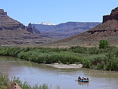
We were on the road around 8:30 a.m. It was sunny, not much more than 5 ░C! We
stopped at the Visitor Center of Capitol Reef National Park and checked on
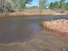
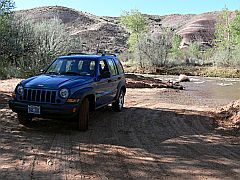
the road conditions for Cathedral Valley. To be able to do the loop drive you have to cross a small river by
car. But they said no problem with a jeep! At 9:15 a.m. we reached the
river ford. I was a bit hesitant to try it as the water seemed quite high,
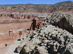
but then we just did it, following the instructions of the ranger, and we made it through without problem! Cathedral
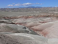
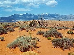
Valley is a 58 miles long dirt road which is still part of
Capitol Reef National Park. We passed through the colourful Bentonite
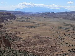
Hills and stopped at Lower South Desert Overlook. Upper South Desert
Overlook a few miles further on was the highlight
with a terrific view.
Then came Upper Cathedral Valley Overlook which looks down upon steep cliffs and
monoliths. By 11:45 a.m. we reached Hartnet Junction which marked about
half way of the tour. By now we had around 20 ░C with sunshine and a cool wind. A few
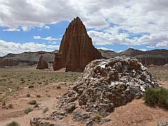
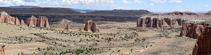
dark clouds appeared, but we were able to leave them behind. Another highlight were Temple of the Sun and Temple
of the Moon and the peculiar Glass Mountain. Once more we passed through
Bentonite Hills with table mountains in the distance.
At 2 p.m. and after a 5 hours drive we were back on Highway 24. We had met
only 7 other cars. |
 |
|
|
|
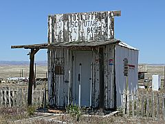
We drove through the Badlands around Caineville and reached the rather
desolate village of Hanksville at 2:15 p.m. We intended to spend the night
at the Wispering Sands Motel but the reception was closed with a sign at
the door "I'll be back soon". At least the cleaning ladies were still
around and they were kind enough to try to contact somebody for us. When
someone came round shortly afterwards we were lucky to get the last room!
Apparently the Wispering Sands was the only hotel in town that was still
operating! The large room was nice enough, but considering the location,
at $77 it was fairly expensive, even though it was a Saturday. We heard
afterwards that Sunday nights were charged at $10 only (!!) and Mondays at
$59.
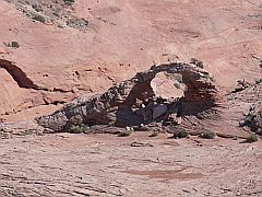
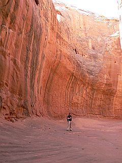
After checking in we drove to Little White
Horse Canyon on the road to Goblin Valley. It was 3:40 p.m. when we started off
at the trailhead. There were quite a number of people around. Bell Canyon is
left, LWHC to the right. We reached the entrance to the canyon after 15 minutes.
After following it for 45 minutes we returned.
 At
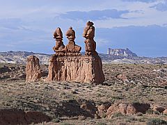
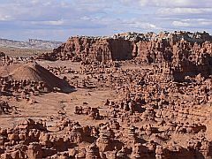
5:45 p.m. we entered Goblin Valley State Park ($6). We spent another 45
minutes walking around between the funny "goblins". The evening light
made for a perfect setting. Back to Hanksville in 30 minutes we had dinner
at the Red Rock Restaurant, following a recommendation on the internet.
And it was surprisingly good. We had TodayÆs Special, chicken and mashed
potatoes with vegetables and soup for $8. At
5:45 p.m. we entered Goblin Valley State Park ($6). We spent another 45
minutes walking around between the funny "goblins". The evening light
made for a perfect setting. Back to Hanksville in 30 minutes we had dinner
at the Red Rock Restaurant, following a recommendation on the internet.
And it was surprisingly good. We had TodayÆs Special, chicken and mashed
potatoes with vegetables and soup for $8.
|
|
|
 |
 |
 |
 |
 |
Sunday, 7th May ¢ Little Egypt ¢ Arsenic Arch ¢
Leprechaun Canyon ¢ Natural Bridges NM ¢ Muley Point ¢ Mokee Dugway -
Goosenecks State Park
Weather: ~25 ░C, sunny
Miles: 247
Accommodation: Four Corners Inn, Blanding
We checked out at 8 a.m. and bought muffins and a coffee
at the petrol station. Then we drove south on Scenic Byway 95. Between Milemarker 20
and 21 we turned off right onto the scenic backway to Bull Creek Pass.
After 1.6 miles on the dirt road we reached Little Egypt where we had our
breakfast. Little Egypt is similar to Goblin Valley but much smaller and
can be visited for free. The red rocks here are streaked with a white band which
makes them perhaps even more interesting. We strolled around for 30
minutes, then returned on the same route and
crossed Highway 95 into the other direction (east). After another 4.4
miles we reached Sahara Sands and from the top of a hill we were able to
spot Arsenic Arch in the distance. We tried to hike down to it,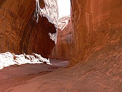 but without a map or GPS it wasn't easy. In the end we gave up as we
didn't want to spend too much time. We were back at the car at
10:45 a.m. and drove back onto the highway. but without a map or GPS it wasn't easy. In the end we gave up as we
didn't want to spend too much time. We were back at the car at
10:45 a.m. and drove back onto the highway.
15 minutes later, at Milemarker 28.2, we turned left
onto a dirt road that was
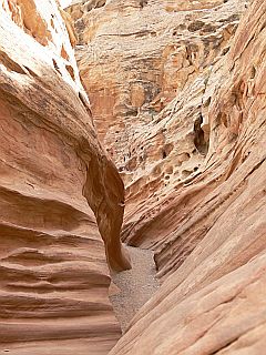
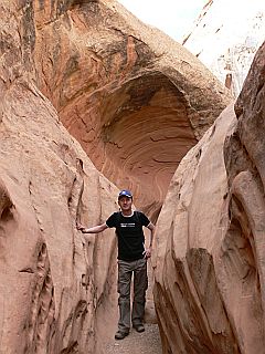
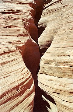
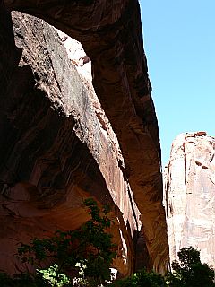
the trailhead to Leprechaun Canyon which we reached after a short hike of 15 or 20
minutes. The first section is very narrow then the canyon widens
with steep walls on both sides. At the end of a narrow tunnel it's hardly possible to
continue so we went back. By 12 p.m. we were on the road again.
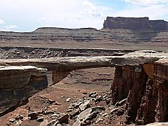
 Driving
through a large canyon with red cliffs we approached the
Colorado. We stopped at a viewpoint looking down onto Glen Canyon
and the bridge crossing the Colorado. Beyond Hite the road becomes rather boring.
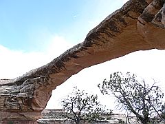
At 2 p.m. we reached Natural Bridges National Monument which we had visited
already in 1998. We did the same loop tour, stopped off at the 3 viewpoints and
hiked the short trail down to Owachomo Bridge (20 mins. return), which is the
oldest and the most impressing of the 3 bridges. Driving
through a large canyon with red cliffs we approached the
Colorado. We stopped at a viewpoint looking down onto Glen Canyon
and the bridge crossing the Colorado. Beyond Hite the road becomes rather boring.
At 2 p.m. we reached Natural Bridges National Monument which we had visited
already in 1998. We did the same loop tour, stopped off at the 3 viewpoints and
hiked the short trail down to Owachomo Bridge (20 mins. return), which is the
oldest and the most impressing of the 3 bridges.
At the
end of an hour we were back on the highway and turned further south onto
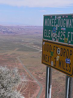
the 261 to Mexican Hat. Shortly before reaching Moki Dugway we turned off to
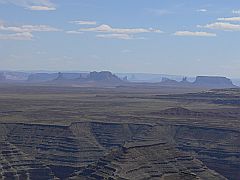
the right onto a dirt track to Muley Point. We reached the viewpoint at 4
p.m. and looked down upon Monument Valley in the distance. Then we drove down Moki Dugway which drops from 6425 to 1100 feet (335m) over 3
miles.
This part of the highway is unpaved. From the viewpoint you can see the Valley of the
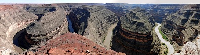
Gods to the left and Monument Valley to the right. At 5 p.m. we reached Goosenecks State Park
(no charge) where you look down upon the loops of the San Juan River.
We found a motel room in Blanding at the Four Corners Inn
($50 incl. tax for a large room with 2 beds and continental breakfast).
Most restaurants and the supermarket were closed on a Sunday, but the Old Tymer Restaurant
was still open until 8 p.m. Their Mexican food was good ($22 with tip).
|
 |
 |
|
 |
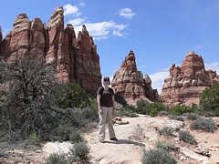
Monday, 8th May ¢ Canyonlands National Park (Needles District)
Weather: 28 ░C, sunny
Miles: 162
Accommodation: La Quinta Inn, Moab
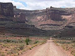
After shopping for some food we left around 8:30 a.m.
for the Needles District in Canyonlands
National Park. From Highway 191 we still had 34 miles to go. At 9:30 a.m. we reached
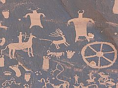 Newspaper Rock
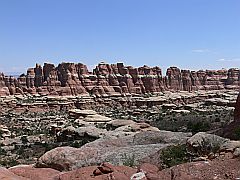
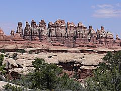
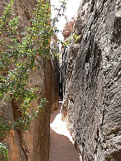
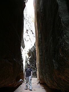
with Indian petroglyphs. An hour later we arrived at the trailhead to Chesler Park
at Elephant Hill. It was sunny and hot. Hiking the 18 km (11 miles) of the
Chesler
Park Loop and Joint Trail took us 6 hours and we were exhausted at the end of
it. The first half was fun and we passed through impressing landscapes,
but the second half which was mostly backtracking the same way we had come
was quite
hard. The highlight before starting the return trip was the so-called Joint Trail
which passes through a narrow cleft. Newspaper Rock
with Indian petroglyphs. An hour later we arrived at the trailhead to Chesler Park
at Elephant Hill. It was sunny and hot. Hiking the 18 km (11 miles) of the
Chesler
Park Loop and Joint Trail took us 6 hours and we were exhausted at the end of
it. The first half was fun and we passed through impressing landscapes,
but the second half which was mostly backtracking the same way we had come
was quite
hard. The highlight before starting the return trip was the so-called Joint Trail
which passes through a narrow cleft.
 Afterwards
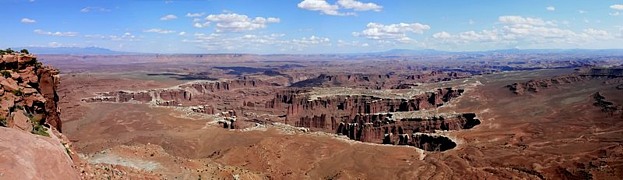
we drove to the end of the main park road at Big Spring Canyon Overlook
but this wasn't very interesting as it only looks down into a small canyon.
Shortly after 5 p.m. we were on our way to Moab where we arrived at 6:40 p.m. As
an outdoor hub Moab's hotels can fill quickly so we had booked in advance at
the La Quinta Inn. The room was nice and large with 2 beds, a
fridge, coffee maker, W-LAN connection. There was also a pool and spa and
they offered a luxury continental breakfast. Thus it was worth the price ($86 + tax for
the first 3 nights, $93 + tax for the last night). Unfortunately the hotel
was a bit further from the actual town centre than we thought. So it was more
convenient to take the car to drive to the restaurants. This night we went to Eddie McStiffÆs
Brewery. I had a Spinach Walnut Salad with chicken which was very good. Afterwards
we drove to the end of the main park road at Big Spring Canyon Overlook
but this wasn't very interesting as it only looks down into a small canyon.
Shortly after 5 p.m. we were on our way to Moab where we arrived at 6:40 p.m. As
an outdoor hub Moab's hotels can fill quickly so we had booked in advance at
the La Quinta Inn. The room was nice and large with 2 beds, a
fridge, coffee maker, W-LAN connection. There was also a pool and spa and
they offered a luxury continental breakfast. Thus it was worth the price ($86 + tax for
the first 3 nights, $93 + tax for the last night). Unfortunately the hotel
was a bit further from the actual town centre than we thought. So it was more
convenient to take the car to drive to the restaurants. This night we went to Eddie McStiffÆs
Brewery. I had a Spinach Walnut Salad with chicken which was very good.
|
 |
Tuesday, 9th May ¢ Potash Road, Canyonlands National Park
(Island in the Sky)
Weather: 18-25 ░C, a.m. cloudy, p.m. sunny
Miles: 118
Accommodation: La Quinta Inn, Moab
 After
breakfast we left Moab at 9 a.m. going north and turned off into Potash Road
just after the bridge across the Colorado. It was a cloudy morning and we were hoping it would clear
up before we reached the Island in the Sky district in the northern part of Canyonlands National Park. We
stopped at a couple of petroglyphs and some dinosaur tracks. By 9:40 a.m. we reached the parking
area at the trailhead
to Corona Arch. It's a 1.5 miles (one-way) trail. Pinto
Arch can be seen in the distance and just before Corona Arch the trail passes
under Bow Tie Arch. After 35 minutes we reached the
base of Corona Arch which is really impressive. It is also known as Little Rainbow Bridge. By 11 a.m. we were back on Potash Road and passed by Jug
Handle Arch and the Potash factory. This was the end of the paved road. The dirt road
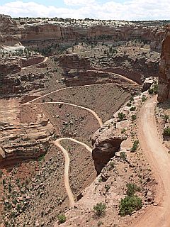
that followed should only be entered with a high-clearance vehicle, if not 4-wheel-drive. Before taking on Shafer Trail we turned off to Gooseneck
Overlook (500 m trail), where you look down upon the Colorado river 700 feet
below, and to Musselman Arch (100 m trail). Then up the Shafer Trail Road to
Island in the Sky: 1400 feet elevation over a very rough and narrow dirt track. I was glad
when we had safely made it! It was 2 p.m. and by now the sun was back. We had approx. 25
░C. After
breakfast we left Moab at 9 a.m. going north and turned off into Potash Road
just after the bridge across the Colorado. It was a cloudy morning and we were hoping it would clear
up before we reached the Island in the Sky district in the northern part of Canyonlands National Park. We
stopped at a couple of petroglyphs and some dinosaur tracks. By 9:40 a.m. we reached the parking
area at the trailhead
to Corona Arch. It's a 1.5 miles (one-way) trail. Pinto
Arch can be seen in the distance and just before Corona Arch the trail passes
under Bow Tie Arch. After 35 minutes we reached the
base of Corona Arch which is really impressive. It is also known as Little Rainbow Bridge. By 11 a.m. we were back on Potash Road and passed by Jug
Handle Arch and the Potash factory. This was the end of the paved road. The dirt road
that followed should only be entered with a high-clearance vehicle, if not 4-wheel-drive. Before taking on Shafer Trail we turned off to Gooseneck
Overlook (500 m trail), where you look down upon the Colorado river 700 feet
below, and to Musselman Arch (100 m trail). Then up the Shafer Trail Road to
Island in the Sky: 1400 feet elevation over a very rough and narrow dirt track. I was glad
when we had safely made it! It was 2 p.m. and by now the sun was back. We had approx. 25
░C.
We did the 20 mins. trail (return) to Mesa Arch with the snowy La Sal
Mountains in the background. Then we drove to Green River Overlook and Upheaval
Dome. The latter is only worthwhile if you want to hike to the crater which
takes around 30 mins. one-way. But as it was 4 p.m. already, we didn't take on the
hike. We drove to Buck Canyon Overlook and Orange Cliffs Overlook. The afternoon
light was great at Buck Canyon, but at Orange Cliffs the light was coming from
the wrong side.
From Grand View Point Overlook you could look as far as the Needles. Then we
returned to Moab. We didn't visit Dead Horse Point State Park ($7) as we
probably had a similar view from Potash Road already. At 5:40 p.m. we were back at the
hotel. For dinner we went to the Moab Brewery which was just a short walk
opposite our hotel. We had to wait a few minutes
before we got a seat as it was busy. With the sun setting as late as 8 p.m. at this time of
year, we didn't get round to watching a sunset yet. But at least it didn't get dark
early.
|
 |
|
|
Wednesday, 10th May ¢ Morning Glory Arch ¢ Fisher Towers ¢
La Sal Mountains Loop
Weather: 26 ░C, sunny
Miles: 124
Accommodation: La Quinta Inn, Moab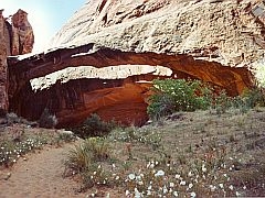 Once
again we left Moab to the north and turned off onto the Colorado
River Road. It was around 9 a.m. The sky was a perfect blue, 26 ░C. After a 15 minutes
drive we parked the car at the trailhead to Morning
Glory Arch and Negro Bill Canyon. The 2-miles trail (one-way) along a small
creek took us around 1 hour. The arch is also known as Morning Glory Bridge, but
it is an alcove arch, the sixth longest arch in the US. Once
again we left Moab to the north and turned off onto the Colorado
River Road. It was around 9 a.m. The sky was a perfect blue, 26 ░C. After a 15 minutes
drive we parked the car at the trailhead to Morning
Glory Arch and Negro Bill Canyon. The 2-miles trail (one-way) along a small
creek took us around 1 hour. The arch is also known as Morning Glory Bridge, but
it is an alcove arch, the sixth longest arch in the US.
At 11:30 a.m. we were on the road
again and 30 minutes later we reached the Fisher Towers which are best
viewed in the afternoon though. The 2.5 miles trail, however, can become very hot in
the afternoon, especially in summer, as it is exposed to the sun. But we
didn't feel like going on another hike right then. We
drove to Cisco ghost town at the I-70 instead. On the way we passed
historic Dewey Bridge which dates of 1910. We reached Cisco at 1 p.m. but
it wasn't
really worth the long drive. The town site is privately owned so that you can't just
walk around, besides it looked more or less like a large dump with tumbledown
houses and cars.
At 2 p.m. we turned onto the La Sal Mountains Loop which winds
up from Castle Valley with a view of the snow-covered mountain caps. A round
trip from Moab on this road is around 60 miles. At 3 p.m. we were back at the
hotel and I tried out the pool and spa. For dinner we went to Zax which has a
good pizza and salad bar.
|
 |
 |
 |
 |
Thursday, 11th May ¢ Arches National Park
Weather: 29 ░C, sunny
Miles: 57
Accommodation: La Quinta Inn, Moab
On Thursday we left by 9:15 a.m. towards Arches NP, my
favourite park. Last time we only had an afternoon to visit it, this time we
wanted to make up for what we had missed. Nevertheless we revisited the Windows
Section with North and South Window, Turret Arch and Double Arch. Then we drove
to Devils Garden 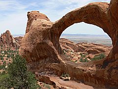 where the
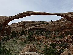
park road ends. At 11:15 a.m. we started off at the trailhead to Landscape Arch.
It's supposedly the longest arch in the world, but who knows how long it will
still resist erosion... Wall
Arch collapsed in 2008. We continued the trail to Double O Arch, then returned the
same way and were back at the parking area after a total of 3 hours. The trail
was moderate with pretty views and several arches on the way. A round trip is
also possible via a primitive trail. where the
park road ends. At 11:15 a.m. we started off at the trailhead to Landscape Arch.
It's supposedly the longest arch in the world, but who knows how long it will
still resist erosion... Wall
Arch collapsed in 2008. We continued the trail to Double O Arch, then returned the
same way and were back at the parking area after a total of 3 hours. The trail
was moderate with pretty views and several arches on the way. A round trip is
also possible via a primitive trail.
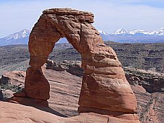
This time we also wanted to hike to Delicate
Arch, which is featured on many of Utah's number plates. At 3:10 p.m.
we started off at the trailhead. For the 146m elevation over 1.5 miles we needed 35
minutes. By now it was pretty warm and there was no shade. Delicate Arch is
best viewed in the late afternoon or at sunset. It made for a beautiful picture with
the snowy La Sal Mountains in the background. At 5 p.m. we were back at the car,
then we returned to Moab. For dinner we went to the Moab Brewery again.
|
 |
 |
 |
 |
Friday, 12th May ¢ Monument Valley, Little Coal Mine Canyon
Weather: 25-28 ░C, sunny
Miles: 311
Accommodation: Cameron Trading Post, Cameron
Today was a long drive. We left Moab at 8:45 a.m. under a
perfect blue sky. We went south, passing by Wilson Arch and the Navajo Twins in
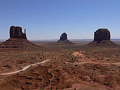
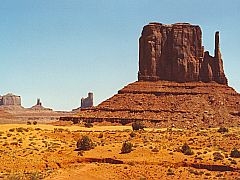
Bluff and arrived at Monument Valley Tribal Park at 11:45 a.m. The park belongs
to the Navajo Indians. There's a fee of $5 per person. We did the 17-miles round trip
on the dirt road in less than 1.5 hours. I would recommend a 4-wheel-drive for
that. The views were nice enough, but there's not that much more to see really
than what you already see from the viewpoint at the Visitor Center. In Kayenta we
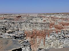
turned west onto Highway 160. At Tuba City we turned off onto Highway 264
towards Keams Canyon. After 15 miles on that road, just before milepost 337, a
dirt road turns off to the left (there's no sign). Another 500m towards the
windmill, then Coal Mine Canyon appears. It's similar to Bryce Canyon, much
smaller but more colourful.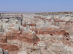
Back
on the 160 we turned south onto the 89 to Cameron which we reached shortly after 4 p.m.
(3 p.m. Arizona time). As there are not many alternative accommodations in
this area, we had prebooked a room at the historic Cameron Trading Post for $84
incl. tax. The rooms are very nice and large. We had 2 beds, a coffee
maker, HBO and a view of the Little Colorado River Gorge from the balcony.
The shop and restaurant are very touristy, but the food was good. I tried
the local speciality Navajo Taco (fried bread with beef, beans, lettuce,
tomatoes, cheese, chili). We spent $26.50 including tip. From our room we
were able to observe the sunset, finally.
|
|
|