|
Saturday, June 6 - Lassen Volcanic Park
Weather: up to 31 °C a.m. sunny with a few clouds, p.m.
cloudy and some rain
That morning we got up early as thunderstorms had been
announced for the afternoon. After breakfast in our room we left at
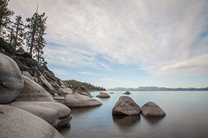
6:30 and 30 minutes later we were at Lake Tahoe. We were looking for
the famous Bonsai Rock but may not have found it. Instead we used
some other rocks for the foreground in some of our photos.
1.5 hours
later we were back in Carson City. We didn't plan to make the side trip to
Virginia City as this would have taken too much time. We passed
through Reno on the Interstate and arrived in Susanville and
California around 10
a.m. where we picked up some bagels and coffee.
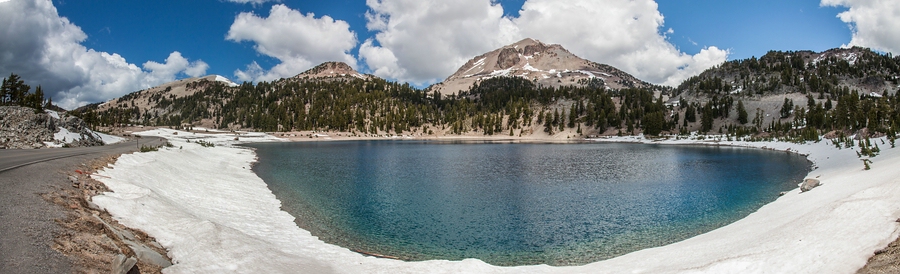
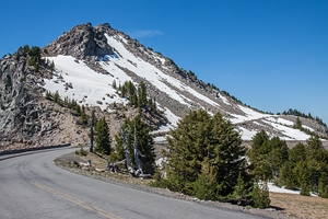
We entered Lassen Volcanic Park
through its south entrance at 11:45
a.m. The park fee is $20 but this was covered by our annual pass. We
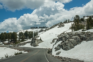
followed the road through the park. There was still some snow at the
higher elevations (2600 m / 8500 feet) and the Bumpass Hell trail was
still closed. Up here we had 10 °C. We had some pretty views of the
snowcapped Lassen Peak from the northern side. After 1.5 hours we
left via the north entrance. It was 1:15 p.m.
On highway 44 we
turned south until we get onto the 6 miles long dirt road to Butte
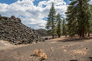
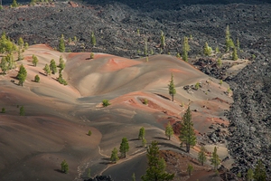
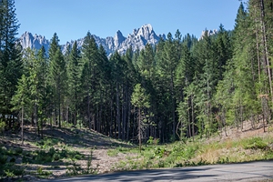
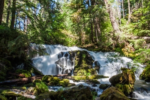
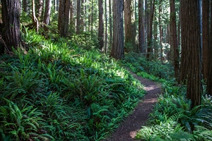
Lake. After a short lunch break we started on the Cinder Cone Trail.
It was 2:30 p.m. and down here we had 25 °C. The huge old lava flows
were impressive.
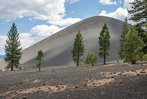
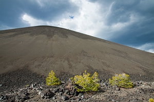
After 30 minutes we reached the bottom of Cinder Cone. Then it was a climb
with 200 m elevation on loose gravel to get to the top. It took me
30 minutes. Volker did it in half the time. By then dark clouds
had come up and there was a light drizzle. We were hoping that we
wouldn't get any lightning! But the rain stopped again soon and the sun came out again
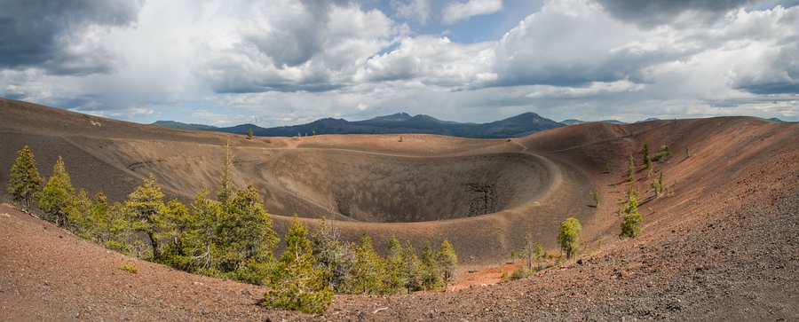
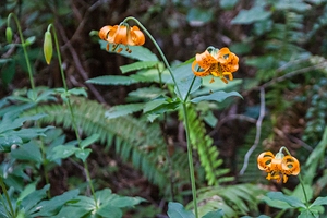
between clouds. We had a great view onto the Painted Dunes
from above and Lassen Peak in the distance. Eventually we followed the path down on
the other side which was even steeper. Then we moved around Cinder
Cone to get back on the trail to our car. By then it was almost 6 p.m. The
hike was 4 miles (6.4 km) with 258 metres elevation.
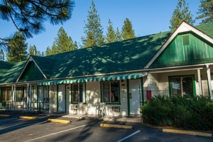
We drove
north towards Burney which we reached at 6:45 p.m. We had reserved a
room with king-size bed at the Green Gables Motel. For dinner we
went to the Outpost Restaurant across the street where we had salmon fillets with mashed potatoes
and vegetables.
Miles
covered: 325
Animals: 1 deer
Accommodation: Green Gables Motel, Burney ($89 plus
tax)
Sunday, June 7 - McArthur-Burney Falls, McCloud Falls, Mount
Shasta
Weather: 38 °C sunny
The motel provided a continental breakfast with cereals, pastries,
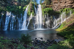
juice, coffee. We left at 8 a.m. and had just a short drive to McArthur-Burney Falls
State Park ($8). Part of the falls were still in shade but
nevertheless it was a beautiful sight.
At 9 a.m. we
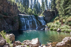
continued north on highway 89. After 30 minutes we reached the
turn-off to Lower
McCloud Falls. It’s just a small
waterfall, not very impressive. Instead of following the trail along
the river towards Middle Falls, we took to the road again. From the
parking area it was just a 10 minutes’ walk to the bottom of the
waterfall which was a great sight. We made another stop at Upper
Falls which were not too impressive.
At 11 a.m. we returned
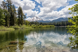
to the highway and soon after reached the town of
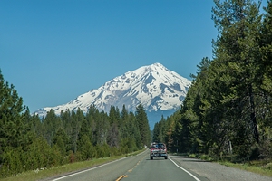
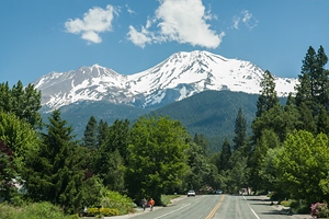
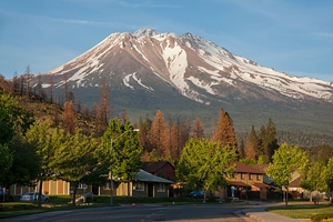
Mount
Shasta with the snowcapped mountain of the same name in the
backdrop. They had a yoga festival that weekend. We had lunch with
wraps and coffee at an organic food grocery. Then we took the
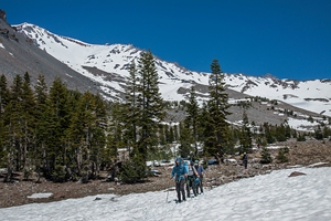
Everitt Memorial Highway to make the climb to the slopes of Mount
Shasta. At 1 p.m. on a sunny Sunday we were lucky to find a parking
space at Bunny Flat at 2100 metres (7000 feet) elevation. It was 23
°C. We followed the Bunny Flat trail 1.6
miles to Horse Camp and back again. There’s an unmaintained mountain
hut at Horse Camp where a bunch of mountain climbers and
snowboarders were taking a rest. After 1 hour and 40 minutes we were
back at the car.
At 3 p.m. we drove south to Dunsmuir.
From the parking area at the Dunsmuir Ave/Siskiyou Ave exit it was
just a 5 minutes’ walk to Hedge Creek Falls which didn’t have much
water though. You can stand behind the waterfall. Here we had 38 (!)
°C so it would have been nice to cool off a little.
At 4 p.m.
we drove south on I-5 to Castle Crags State Park
($8). A narrow one-way lane took us up to a Vista Point towards the
Castle Crags and Mount Shasta. Then we followed the easy
Root
Creek trail (1 mile one-way) through the woods to a little
waterfall. We didn’t see any wild orchids though.
It was 6
p.m. when we left the park and drove back to Mount Shasta. Here we
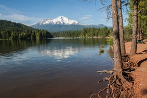
turned off to Lake Siskiyou. From the lake you can get a fantastic
view of Mount Shasta, in particular at sunset.
It’s a few
more miles to Weed where we had a reservation at Motel 6 for a
(remodeled) room with two double beds. For dinner we had Mexican
(super burritos with shredded beef/chicken and a Margarita) at Dos
Amigos at the other end of town. The Chinese waiter thought we were
Russian - „Doswidanja!“
Miles covered: 159
Animals: none
Accommodation: Motel 6 Weed ($62 plus tax)
Monday, June 8 - Crater Lake, Rogue River Gorge, Jacksonville
Weather: 42 °C sunny
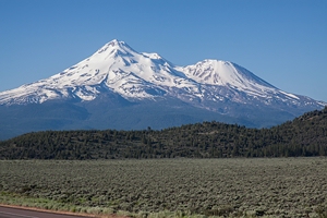
We had breakfast in our room and left Weed at 7:30 a.m. The view of
Mount Shasta along the road north to Klamath Falls was fantastic. We
crossed the border into Oregon. At 9 a.m. in Klamath Falls we did
some shopping and stopped at a coffee shop for bagels and coffee.
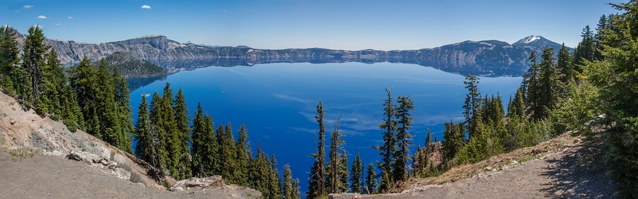
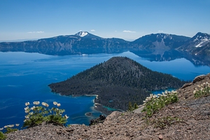
At 11 a.m. we entered Crater Lake
National Park ($15 but included in the national park’s pass). We
stopped at Watchman Overlook but the trail up to Watchman Tower was
still closed due to snow and the East Rim Drive was also still
closed for the season. We made another stop at Rim Village. From
here we had a great view of the lake with a mirror effect of Wizard
Island and the crater rim. It was 23 °C. Then we drove to Vidae
Falls and had some lunch at the nearby picnic area.
At 12:30
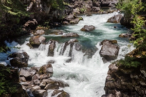
p.m. we left the park towards Medford. On OR 62 we stopped at Rogue Gorge.
It was 1:15 p.m. From the parking area a short, easy trail follows
the Rogue River to several viewpoints. At Union Creek Resort we
stopped for an ice-cream (Huckleberry Cheesecake and Peanut Butter
Chocolate - yummy!). Then we parked at Natural Bridge and followed
the trail to some more viewpoints along the Rogue River which flows
through a lava tube at this spot.
At 2:30 p.m. we reached
Prospect and stopped at the parking area for Mill Creek Falls. It’s
a short walk to the cliff from where you can see the 54 metres high
waterfall. Almost next to it is the 60 metres high Barr Creek Falls.
It was hot down here: 36 °C. But the trail is in shade. A little
further along the road into Prospect is another unmarked parking
area with a few picnic tables. From here another forest trail leads
to pretty Pearsony Falls within 5 minutes.
At 3:30 p.m. we
were back on the road going south on highway OR 62. We stopped at
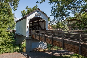
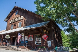
Peyton Bridge across Lost Creek Lake and in Eagle Point at the
historic Butte Creek Mill of 1872 and Antelope Creek Covered Bridge
of 1922.
At 4:30 p.m. we were back in the car, crossed I-5
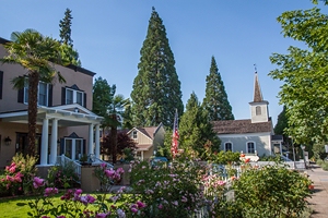
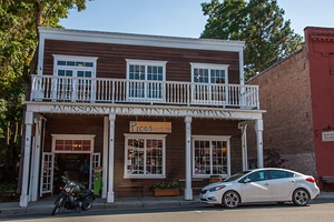
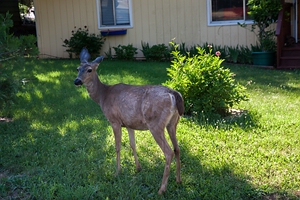
and reached Jacksonville at 5 p.m. Here we walked around the
historic center at California Street. But at 42 °C it was too hot to
linger. When we drove along the streets we suddenly saw a deer in
someone’s front yard!
At 6 p.m. we arrived at the Best
Western Horizon Inn in Medford and took a refreshing dip in the
pool. We had dinner at the Black Bear Diner just across the parking
area (burger and BBQ ribs).
Total miles: 247
Animals: 1
deer
Accommodation: Best Western Horizon Inn, Medford ($92 plus
tax AAA rate)
Tuesday, June 6 - Covered Bridges in Myrtle Creek and Sea Stacks
at
Bandon
Weather: 26 °C inland, 18 °C at the coast, sunny
The hotel had a hot breakfast: waffles, biscuits and gravy, cereals,
toast, muffins, bagels, yoghurt, fruit. We left at 9 a.m., did some
shopping and turned north on I-5. At 11 a.m. we turned off at Myrtle
Creek to see two covered bridges (Horse Creek Covered Bridge and
Neal Lane Covered Bridge). We had 26 °C.
South of Roseburg we
turned onto OR 42 and followed our old route from September 2010
back to the coast, passing by Sandy Creek Covered Bridge. Back then
we had fled the coastal fog at Coos Bay. Our new destination was
Bandon. Upon leaving Myrtle Point we stopped at
Mill Pond Wayside for a picnic lunch with lake view.
At 1:30
p.m. we arrived at the coastal town Bandon and had a stroll around
Old Town. It was sunny but with a strong cold wind. We checked into
our hotel Bandon Inn overlooking the Old Town. It was a beautiful,
large room with two queen-size beds and a balcony with harbor view.
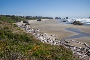
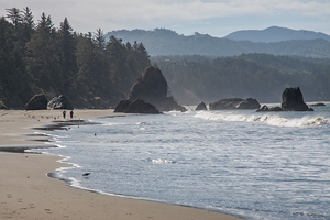
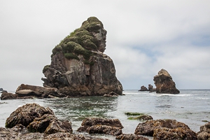
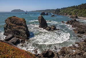
However, we didn’t linger but drove to Coquille Point south of the
town center. We took the stairs down to the beach which has some
nice sea stacks. But it was past low tide so we couldn’t find any
tide pools. But we saw a few seals on the rocks. A short drive
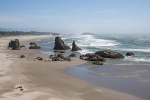
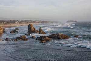
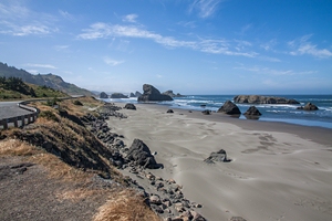
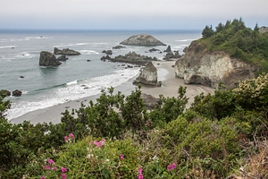
further south took us to Face Rock State Scenic Viewpoint. From here
you get a beautiful view of the beach with some sea stacks and
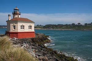
another set of stairs leads down to the beach. Then we drove back
through town and at its northern end we turned off towards Bullards
Beach State Park. At the end of the road you will find Coquille
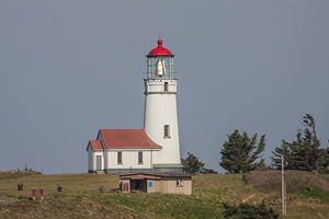
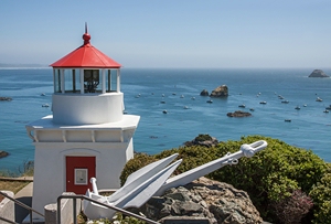
River Lighthouse with a view of Bandon town.
At 4 p.m. we
headed back to our hotel, parked the car and walked back to Old Town
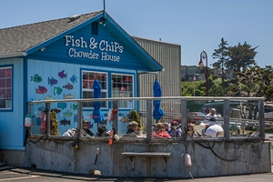
in 5 minutes. It was 5 p.m. We had an early dinner at Bandon Fish
Market with fresh snapper and fries. Then we went back to our room.
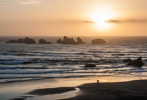
For sunset just before 9 p.m. we drove back to Face Rock. Here we
met with a couple from Austria who we know through a US travel community and we had
a few drinks with them at the Irish Pub in Old Town.
Miles
covered: 192
Animals: seals (and a few horses)
Accommodation:
Bandon Inn, Bandon ($102 AAA rate plus tax)
Wednesday, June 10 -
Samuel H. Boardman State Scenic Corridor, Harris Beach State Park
and Jedediah Smith State Park
Weather: first cloudy at 12 °C,
then coastal fog, later sunny at 18 °C
The continental breakfast at the hotel reception only offered sweet
pastries so we had breakfast in our room instead with cereals, fruit
and coffee. We left at 8:20 going south along the Oregon Coast and
stopped at several viewpoints. At
Cape Blanco
we turned off onto a 3 miles long road to the lighthouse. But the
road ends at a parking area and you have to walk the final stretch.
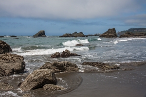
Guided walks start at 10 a.m. We go back to highway 101 and stop at
Battle Rock Wayfinding Point just beyond Port Orford which as some
good sea stacks. Our next stop is Cape Sebastian, then Arch Rock and
Natural Bridge in Samuel H. Boardman
State Scenic Corridor.
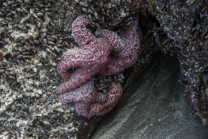
It’s 11:20 a.m. when we get to
Harris Beach
State Park (no entry fee). But we are too early for low tide so we
go to Brookings another mile along the road and have some bagels and
coffee. An hour later were back at Harris Beach. Still we can hardly
find any tide pools and only a couple of big star fish.
After
another hour we continue towards Crescent City.
We cross the border back into California and after an hour‘s drive
we arrive at the Lighthouse Inn where we have reserved a room. It’s
2:20 p.m.
After check-in we hit the road again towards
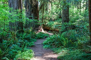
Jedediah Smith State Park which was the
film location for Endor in Star Wars. While we had clouds at the
coast, just a few miles inland the sun was shining from a bright
blue sky. We had 18 °C. At an info center we got some information
about the Redwood Parks in this area. The road to Stout Grove was
closed. But we got directed to Walker Road instead. It’s a gravel
road that ends at Smith River. At 4 p.m. we started on the Pfeiffer
Loop trail (2.5 km) which took us through the forest with giant
trees. There were no other tourists around. After a good 30 minutes
we were back at the car.
At 5 p.m. we managed to get a
parking space at the beginning of the road where the Simpson Reed
Discovery trail starts. The trail is less than a mile and the giant
trees are impressive. After 20 minutes we were back at the car.
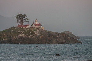
We returned to Crescent City and drove up to Battery Point
Lighthouse built in 1856 and situated on a little island that is
only accessible by road at low tide. It was high tide so we could
only watch it from the beach. In 1964 much of Crescent City was
destroyed by a tsunami. Still people live very close to the water.
We have dinner at Fisherman's Restaurant at the harbor just
opposite our hotel where we have cod and rainbow trout. Then we head
to Pebble Beach Drive to watch the sunset.
Miles covered: 160
Animals: 1 deer
Accommodation: Lighthouse Inn, Crescent City
($99 plus tax)
Thursday, June 11 - Prairie Creek
Redwoods State Park with Fern Canyon,
Trinidad Memorial Lighthouse, Arcata
Weather: sunny at 18 °C
We had breakfast at the hotel with cereals, bagels, toast, English
Muffins, fruit. At 8:15 a.m. we checked out and drove south. Passing
through Klamath we left highway 101 at exit 756 and turned onto
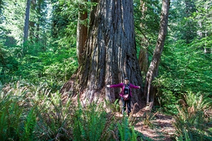
Newton B. Drury Parkway. This led us through a California Redwoods
forest within Prairie Creek Redwoods State Park. There were many
trailheads along the road but it wasn’t easy to identify the one
that the lady at the info center yesterday had recommended.
At 9 a.m. we started in the direction of
Brown Creek
trail (difficulty: easy). Only the distance to the next trail
crossing was signposted. So it was good that we had been given a
map. We turn left onto Rhododendron trail (moderate). At the highest
point of the trail we see a total of 9 banana slugs! Never seen them
before. Then it was downhill on South Fork trail (strenuous if you
go in the other direction). The loop was indicated with 3.5 miles.
According to our gps it was 6.3 km. After 1 hour and 40 minutes we
were back at the car.
We continued through the park. Didn’t
see any elks in Elk Prairie or Elk Meadow. Then we turned off upon
Davidson Road which is a dirt track and an
$8 state park fee is charged (if you don’t own an annual national
park’s pass). Prairie Creek Redwoods State Park, Del Norte Coast
Redwoods State Park, Jedediah Smith Redwoods State Park and Redwood
National Park are managed by the California Department of Parks and
Recreation in cooperation with National Park Service. Along the road
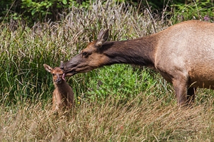
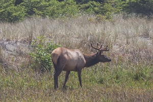
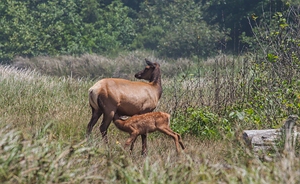
we see three male elks lying in the grass with just their antlers
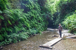
visible and a female elk feeding her calf. After 8 miles we got to a
parking area at the trailhead of Fern Canyon. This is short loop
trail. The steep walls of the narrow canyon are completely covered
in ferns and mosses. We completed the loop in 30 minutes. Then we
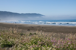
headed to the beach as we had seen some elk overthere. At the
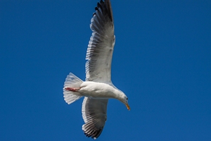
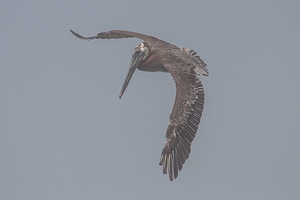
water’s edge we saw many seagulls and pelicans. On the way back we
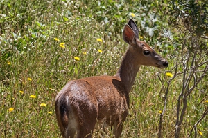
stop at Gold Bluffs Beach picnic area for some lunch and we see a
few deer on the road.
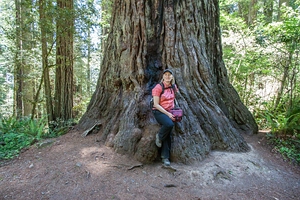
Back on highway 101 we turn off onto
Bald Hills Road to Lady Bird Johnson Grove. It’s just 2.5 miles to
the parking area. This is the start of a 1.5 miles loop trail
through the forest of giant trees. Unfortunately the rhododendrons
were no longer in bloom. We got back to the car in 30 minutes.
At 2:15 p.m. we headed back to highway 101. We made a short
photo stop at Stone Lagoon Schoolhouse. There were some elk nearby.
In Trinidad we visited the Memorial
Lighthouse, a replica of the original lighthouse on Trinidad Head.
Then we turned onto Scenic Drive just south of Trinidad. This is a
narrow road with some steep trails leading down to the ocean. We
stopped at Luffenholtz Point trail which offers some great views
across the coast with its beaches and sea stacks.
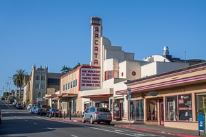
At 4 p.m.
we checked into Best Western Arcata Inn at the northern end of Arcata.
For dinner we headed towards town for an early meal of Japanese Cold
Noodle Salad and Thai Red Curry Soup at Japhy's. Then we visited
Downtown which has a few Victorian homes and murals but didn’t feel
too welcoming. We also had a look at Arcata Marsh and Wildlife
Sanctuary where we saw some white egrets and other birds.
Miles covered: 105
Animals: elk, deer, pelicans, egrets (and
banana slugs)
Accommodation: Best Western Arcata Inn, Arcata ($99
AAA Rate plus tax)
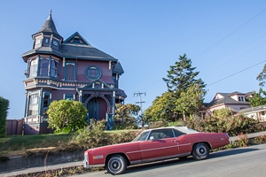
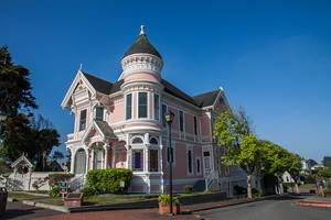
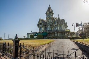
Friday, June 12 - Eureka, Ferndale, Lost Coast, Humboldt
Redwoods State Park, Highway 1, Glass Beach
Weather: up to 38 °C inland, 18 °C at the coast
We had breakfast at the hotel and left at 8:30. It was only a few
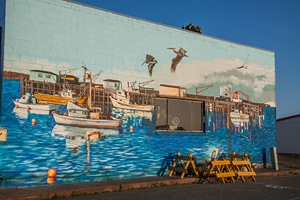
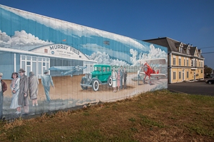
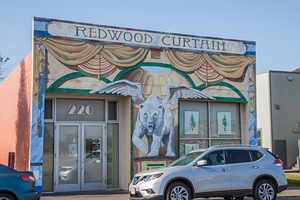
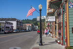
miles to Eureka where we had a look at some Victorian houses: Carson
Mansion and the Pink Lady. Downtown has some great murals. At the co-op
we got some expensive but great bread – like home! Then it was
another 20 miles to Ferndale which still has many Victorian houses
along its Main Street.
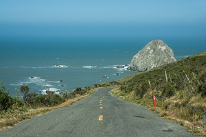
At 10 a.m. we continued on Mattole Road to Petrolia. It’s 30 miles on a narrow, curvy and sometimes
bumpy road. The landscape reminded us of Ireland again. Eventually the
road descended to the coast. There was quite a stormy wind. It was
32 °C. The blue and turquoise color of the water was fantastic. At
Honeydew we followed the signs back to highway 101. It was another 24
miles. After 2.5 hours we finally arrived at the
Humboldt
Redwoods.
We had a picnic lunch. It was 12:30. Then we hiked the Big Trees Loop
(0,6 miles, 15 minutes) and Rockefeller Loop (same distance). At
2:15 p.m. we continued south and soon turned onto Avenue of the
Giants which runs in parallel to highway 101. Temperatures had
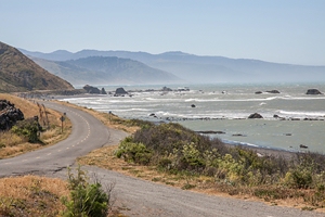
climbed to 38 °C (100 °F). Eventually we turned onto highway 1 which
descends towards the coast in many curves. We stopped at several
viewpoints along the coast. At a Vista Point just beyond Westport we
took a short trail down to the ocean. Here we had 18 °C.
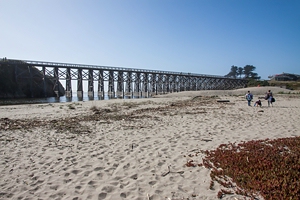
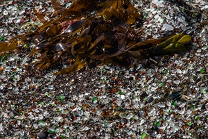
It
was 5:30 p.m. when we got to Fort Bragg. We stopped at Pudding
Creek Bridge and then drove to Glass Beach at the northern end of
town. This was a wonderful sight with the little glass pieces
glistening in the sunlight. At 6 p.m. we checked into the Super 8.
It was Friday evening and waiting time at the North Coast Brewing
Company at 7:30 p.m. was 45 minutes so we went to Los Gallitos
instead, a tiny Mexican restaurant which had good reviews. We had
burritos with chilli verde pork and steak. It was good, and with two
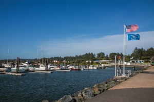
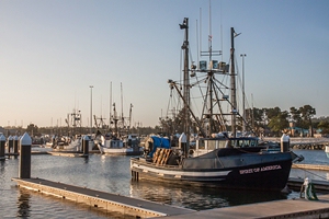
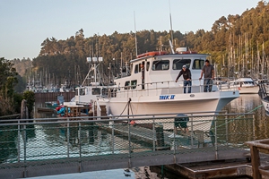
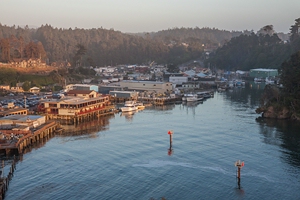
cokes we only paid $22 plus tip. Afterwards we had a look at Noyo
Harbor which was just around the corner of our hotel.
Miles
covered: 196
Animals: 1 deer
Accommodation: Super 8, Fort
Bragg ($105 including discount plus tax)
|