 |
|
The Alps 2015
Königssee, Watzmann and Dachstein –
Bavarian and Austrian Alps
|
||||||
|
Saturday, June 5: drive from Düsseldorf to Flörsheim
After a two hours’ drive we arrive at the Hotel Karthäuser Hof in
Flörsheim near Frankfurt to attend a silver wedding. The hotel is
decorated with movie memorabilia. We pay 72 euros for the double
room plus 6.90 euros per person for breakfast.
Before breakfast we walk down to the banks of the river Main. They
have a dragon boat racing event today. We have breakfast, say
good-bye to our relatives and depart around 11 a.m. It’s a 6 hour
drive to our destination Schönau am Königssee. After a couple of
breaks including one at the beautiful lake Chiemsee we get there
around 6 p.m. and check into the Explorer Hotel Berchtesgaden. The
double room with breakfast costs 90 euros. We need to make a
reservation for dinner as all the nearby restaurants seem to be
fully booked. The receptionist manages to get us a table at the
Seealm at 7 p.m. It’s a 12 minutes’ walk. We have pasta and
dumplings with fresh chanterelles, very good, plus beer and
Federweißer (young wine) for 30 euros plus tip. | ||||||
|
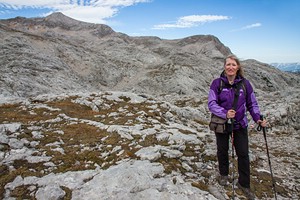
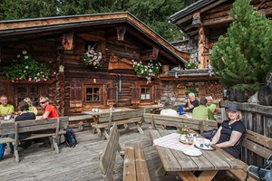
Monday, June 7: hike to Schellenberger Ice Cave Weather: cloudy, 15 °C Breakfast has a good choice. We are ready to leave at 9 a.m. We make a short stop in Berchtesgaden to buy some food, and after a 14 kilometres' drive we arrive at the parking area to the Schellenberger Eishöhle 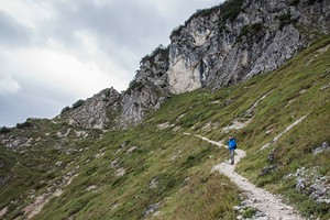 and Toni-Lenz-Hütte between the town of Marktschellenberg and the
Austrian border. It’s 9:50 a.m. when we depart on our hike. It’s an
average ascent of 15% and
970 metres elevation to reach Toni Lenz hut. At the
end of the first hour we leave the jeep road and continue on a
narrow, rocky path, and after 2.5 hours we arrive at the hut. It’s
12:30 p.m.
and Toni-Lenz-Hütte between the town of Marktschellenberg and the
Austrian border. It’s 9:50 a.m. when we depart on our hike. It’s an
average ascent of 15% and
970 metres elevation to reach Toni Lenz hut. At the
end of the first hour we leave the jeep road and continue on a
narrow, rocky path, and after 2.5 hours we arrive at the hut. It’s
12:30 p.m.
 The
hut is situated at an elevation of 1450 metres above sea level and
offers a good view of the valley of Salzburg and the surrounding
mountains. We have a break with lentil soup, beer and red currant
spritzer. The
hut is situated at an elevation of 1450 metres above sea level and
offers a good view of the valley of Salzburg and the surrounding
mountains. We have a break with lentil soup, beer and red currant
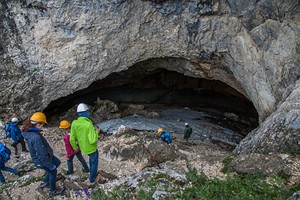
spritzer.Then we continue to the ice cave at 1570 metres which takes us another 20 minutes. There are guided tours every hour which cost 6.50 euros per person with a tourist guest card. We are a total of 12 which is quite a large group but this is the busiest time of day. The cave can only be reached on foot. The tour takes 45 minutes. You have to carry a helmet which is provided and a light which is also provided if you don’t have your own. We use stairs to climb into the cave. The ground and the cave walls are covered with ice. The area that can be visited is not very large and it is better earlier in the year when there is still more ice. But it’s our first time in an ice cave so it’s interesting nevertheless. When we get back out, it is overcast and drizzling. Back at the Toni Lenz hut we have a Kaiserschmarren (pancake) with apple sauce and lingonberry jam which is big enough to share between two and coffee. It’s 3:40 p.m. when we start our hike back down. Going downhill all the way it only takes us 1 hour and 40 minutes until we are back at the car. It’s 5:30 pm. We cross the border into Austria to fill up on petrol which is a little cheaper than in Germany but then we are stuck in a traffic jam as there’s a festival in the next village. As we are not hungry anymore, we just buy a few drinks at the supermarket before heading back to the hotel. | ||||||
|
Tuesday, June 8: e-bike tour into Klausbach valley Weather: first rain, then mostly sunny until late afternoon, 18 °C  We
wake up early but it’s raining outside. For today we have a
reservation for e-bikes from 9 a.m. Finally the rain stops and we
walk to the bike shop. With a discount from our hotel we get two
mountain e-bikes for 28 euros each for the day. It’s 9:30 a.m. when
we head off in the direction of Ramsau and the sun is coming out.
Soon we get our first long downhill ride to the main road to Ramsau.
At Wimbachbrücke (bridge across the Wimbach stream) we turn off at
the parking area and it’s a steep but short way uphill to the pay
station for Wimbachklamm (1.50 euros each with guest card). We lock
up the bikes and walk into the gorge. A wooden path leads through
the narrow gorge with water coming down the walls from all sides.
From the exit the path follows the main hiking trail back to the
entrance. We
wake up early but it’s raining outside. For today we have a
reservation for e-bikes from 9 a.m. Finally the rain stops and we
walk to the bike shop. With a discount from our hotel we get two
mountain e-bikes for 28 euros each for the day. It’s 9:30 a.m. when
we head off in the direction of Ramsau and the sun is coming out.
Soon we get our first long downhill ride to the main road to Ramsau.
At Wimbachbrücke (bridge across the Wimbach stream) we turn off at
the parking area and it’s a steep but short way uphill to the pay
station for Wimbachklamm (1.50 euros each with guest card). We lock
up the bikes and walk into the gorge. A wooden path leads through
the narrow gorge with water coming down the walls from all sides.
From the exit the path follows the main hiking trail back to the
entrance.After 30 minutes we recover our bikes and continue to follow the road to Ramsau and Hintersee. With the e-bikes you hardly feel that it is going slightly uphill. When we arrive in Ramsau, we stop at the village church which is a famous postcard picture with the turquoise Ache stream next to it and the mountains of the Reiteralpe in the background. From Ramsau we take the turn-off to Zauberwald (magic forest). There’s a rather steep ascent but we make it. We arrive at the lake, then it’s downhill again. It’s a very idyllic scenery with rowing boats and ducks on the lake. 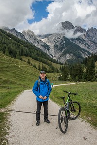 At 11:30 a.m. we arrive at the visitor information for the national park and pass the gate into the valley of Klausbachtal. The narrow road is closed for cars but as a hiker you can take the local bus so you don’t need to return on the same way if you take the hiking path up to Bindalm. We cycle up the road which is quite flat at first until we reach a suspension bridge that was built for hikers in 2010. After a short rest, it’s a steep final ascent to Bindalm which is a primitive Alpine farmers’ hut with summer pastures which also provides snacks for hungry hikers. It’s 12:30 p.m. when we get there. We have bread with cheese (Schüttelkäse) and drinks. They also serve Alpine schnapps (Enzian). The sun is shining but the mountain peaks are still hidden in the clouds. After the break we tackle the final steep kilometre to Hirschbichl at the Austrian border. This is the turning point of our tour. We have covered 22 kilometres from Schönau. The return is downhill all the way. So check your brakes! Instead of going through the Zauberwald again (which would include a hill), we take the road. From Wimbachbrücke we try to find an alternative route away from the main road but we are not successful. So we continue on the road to Berchtesgaden. It’s 3:30 p.m. when we reach the roundabout at the southern end of town. We decide to head into town and have a look at the historic centre. This is pedestrianized so we have to push our bikes. The sun is still shining and we have an ice-cream on the market square (Marktplatz). Then we return to Schönau along the Königsseer Ache which is a flat gravel path along a stream that flows into Lake Königssee. At 4:45 p.m. we return our bikes and it’s another 15 minutes’ walk back to our hotel. Our muscles are a bit tired by now and our butt hurts from the small bicycle seats. We have covered a total of 55 kilometres. We decide to stay at the hotel for dinner. They offer some snacks such as sandwiches or Flammkuchen (tarte flambée which are a kind of thin pizza from Alsace). We have the traditional Flammkuchen with sour cream, chopped leeks and bacon (6.50 euros). Wednesday, June 9: boat trip on Lake Königssee and hike to Röthbach waterfall Weather: mostly cloudy with some sun in the late morning, 17 °C 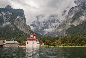 After
breakfast we walk to Lake Königssee in approx. 20 minutes. Tickets
to the other side of the lake at Salet cost 16.90 euros per person.
We depart at 8:50 a.m. The boat is full. The boat service across the
lake exists since 1909. The boats are electric and thus silent. We
are on the oldest boat called "Watzmann" like the mountain. It stops
for the famous echo and the conductor plays the trumpet to
demonstrate the effect. After 40 minutes we arrive at St. Bartholomä
but we remain in the boat until we have reached the southern end of
the lake after almost an hour. After
breakfast we walk to Lake Königssee in approx. 20 minutes. Tickets
to the other side of the lake at Salet cost 16.90 euros per person.
We depart at 8:50 a.m. The boat is full. The boat service across the
lake exists since 1909. The boats are electric and thus silent. We
are on the oldest boat called "Watzmann" like the mountain. It stops
for the famous echo and the conductor plays the trumpet to
demonstrate the effect. After 40 minutes we arrive at St. Bartholomä
but we remain in the boat until we have reached the southern end of
the lake after almost an hour. Here we take the path to Lake Obersee and Fischunkelalm. 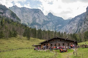 It’s still quiet at this time of day and the sunlight is glistening
on the lake. After 40 minutes we have reached the southern end of
the lake and it’s another 30 minutes uphill to Röthbachfall,
Germany’s highest waterfall (470 metres) at the end of the valley.
However, it doesn’t have much water at this time of year. It’s 11
a.m. and the sun now disappears behind the clouds. As we return, we
stop at Fischunkelalm for some bread with bacon and cheese and a
glass of fresh milk from happy Alpine cows.
It’s still quiet at this time of day and the sunlight is glistening
on the lake. After 40 minutes we have reached the southern end of
the lake and it’s another 30 minutes uphill to Röthbachfall,
Germany’s highest waterfall (470 metres) at the end of the valley.
However, it doesn’t have much water at this time of year. It’s 11
a.m. and the sun now disappears behind the clouds. As we return, we
stop at Fischunkelalm for some bread with bacon and cheese and a
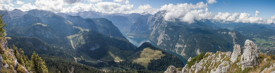
glass of fresh milk from happy Alpine cows. On the hike back to Salet we are met with a crowd. It’s 1:15 p.m. when we board the next boat and return to St. Bartholomä. Here we get off to visit the famous chapel. The Watzmann is hiding behind the clouds so we cannot see it and we don’t feel like making the hike to the “Eiskapelle”, the mouth of the glacier at the base of the mountain. It’s 2:35 p.m. when we return to the boat terminal at Königssee where we arrive at 3:10 p.m. We have an ice-cream at one of the stalls and walk back to the hotel. We ask reception to book us a table at Grünsteinstüberl for dinner. It’s a 15 minutes walk. The restaurant is cosy and it even has Bavarian live music tonight (not really our taste though). We have to wait for our order quite a long time but they offer us a free Enzian schnapps. We have pork fillet and goulash with spaetzle (a local kind of pasta) plus 3 drinks for 36 euros plus tip. The food was good. Thursday, June 10: Hike to the Jenner summit Weather: mostly sunny with some clouds, 18 °C This morning starts with fog in the valley. But checking the webcams, we see that the mountains are free of clouds. After breakfast we check out of the hotel (when we made the reservation we thought we might be able to extend for a couple of days but then the hotel was fully booked) and drive up the hill to our next accommodation at Pension Grünsteinblick. We are able to check in early as we would be back too late in the afternoon (check-in until 4 p.m.). We pick up the keys and guest card and leave our luggage in the storage room. From here we have a good view of the Watzmann while the valley is still shrouded in fog. We leave towards Obersalzberg and get a discount on the parking fee at Hinterbrand with our guest card. We pay 1.50 euros for the day. At 10:10 a.m. we start on our hike. Just before arriving at the halfway station of the Jenner cable car, we take a steep path to the left, then we should have continued to Mitterkaseralm on a broad forest trail, instead we make a short detour across a cow pasture, but we still get to the Alm. We reach it at 11:30 a.m. From here the trail follows a tarred, narrow road up to the upper station of the Jenner cable car. At the end of another hour we are standing on top of the Jenner mountain (1874 m) with a 360 degrees view down to Lake Königssee, Schönau, and Germany’s second highest mountain, the Watzmann. The 6 kilometers’ hike with 760 metres elevation took us nearly 2.5 hours to complete. | ||||||
 | ||||||
|
On the return we stop for lunch at the mountain top restaurant of
the Jenner cable car which has a large open-air terrace. We have pea
soup and traditional Bavarian veal sausages with a pretzel for 17
euros plus drinks. It’s 1:50 p.m. when we continue our hike. The trail now continues to Schneidsteinhaus, another mountain hut, and offers great views. After 30 minutes we arrive at the hut which also offers food and drinks. But we descend on a broad path and at 3 p.m. we reach a junction that leads to Gotzentalalm on the left and Königsbachalm on the right. We go to the right as this also leads back to the Jenner half-way station and the Hinterbrand car park. There’s another Alm on the way where we stop for a glass of fresh milk for just 1 euro each. We sit outside in the sunshine with a view of cows, pastures and mountains in the clouds. We needed 2.5 hours for the descent. At 4:40 p.m., after 6.5 hours, 16 kilometres and 890 metres elevation we are back at our car. We return to Berchtesgaden and buy some drinks and sandwiches for dinner at the supermarket. Then we return to our new accommodation that’s not far from the lower station of the Jenner cable car. Our room is decorated in Bavarian style. They have free wifi and we even have a small balcony with Watzmann view. Friday, June 11: Hike to Eagle's Nest and Rossfeld Panorama Road Weather: mostly sunny, 20 °C in the valley, cooler in the mountains 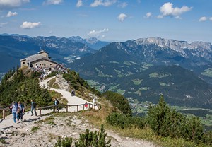 Breakfast
is good with fresh rolls, cheese, cold meats, cut vegetables
(tomatoes, cucumber, red or green peppers), boiled eggs, muesli,
fresh fruit, coffee, various juices, etc. After breakfast we drive
to Berchtesgaden and turn onto Rossfeldstraße. There’s a charge of 7
euros for a car with two passengers on this panoramic road. After
the first two kilometres we park at Ofnerboden from where we start
our hike to Kehlsteinhaus. It’s 9:50 a.m. We follow a forest road
which becomes an old tarred road that winds up the mountain. After
1.5 hours we have reached the bus terminal at the elevator that goes
up right into Kehlsteinhaus which is also called the Eagle's Nest.
The bus ride along the spectacular Kehlsteinstraße costs about 14
euros with a guest card. The golden elevator was built during
Hitler’s reign and goes up 124 metres within the mountain. But we
take the foot path instead which offers fabulous views down into the
valley and towards the Watzmann. The sun shining from a blue sky and
the view is clear. After another 25 minutes we have reached
Kehlsteinhaus at 1834 metres elevation. Up to here we have walked
5.8 kilometres with a 630 metres elevation gain. Breakfast
is good with fresh rolls, cheese, cold meats, cut vegetables
(tomatoes, cucumber, red or green peppers), boiled eggs, muesli,
fresh fruit, coffee, various juices, etc. After breakfast we drive
to Berchtesgaden and turn onto Rossfeldstraße. There’s a charge of 7
euros for a car with two passengers on this panoramic road. After
the first two kilometres we park at Ofnerboden from where we start
our hike to Kehlsteinhaus. It’s 9:50 a.m. We follow a forest road
which becomes an old tarred road that winds up the mountain. After
1.5 hours we have reached the bus terminal at the elevator that goes
up right into Kehlsteinhaus which is also called the Eagle's Nest.
The bus ride along the spectacular Kehlsteinstraße costs about 14
euros with a guest card. The golden elevator was built during
Hitler’s reign and goes up 124 metres within the mountain. But we
take the foot path instead which offers fabulous views down into the
valley and towards the Watzmann. The sun shining from a blue sky and
the view is clear. After another 25 minutes we have reached
Kehlsteinhaus at 1834 metres elevation. Up to here we have walked
5.8 kilometres with a 630 metres elevation gain.
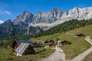
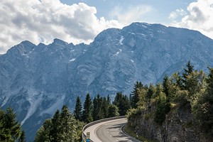 It’s 12 p.m. Time for lunch. We take a seat on the large sunny terrace at the mountain restaurant and enjoy barley soup (Gerstensuppe) and Leberkäse (meat loaf) with potato salad. Then we walk up to the summit cross and start on the Kehlstein-Rundweg which leads us in a loop on narrow paths, ladders and stairs through a rock landscape at the mountain top. Here we are far away from the crowds at the restaurant and museum. At the end of an hour we take the same way back down and after another hour and 20 minutes we are back at the car. It’s 3:30 p.m. In total we have covered 13 kilometres with an elevation gain of 840 metres. Now we continue on the Rossfeld road which offers some great views of the mountains. At the highest point at 1570 metres there’s a short panorama trail, just at the border to Austria and you can see the Salzburger Land and the Dachstein mountains on the other side. These will be our destination of the coming days. We take the road back down into Berchtesgaden, and by 5 p.m. we are back at our accommodation. We take a shower and drive down to Restaurant Echostüberl at Lake Königssee which offers fresh fish from their own smokehouse. We have the grilled Bachsaibling with boiled potatoes and a side salad. With a Federweißer and a non-alcoholic beer we pay 46 euros plus tip. Saturday, September 12: Hike to Watzmannhaus Weather: sunny, 24 °C The weather today is perfect for our grand hike. After breakfast we drive to Hinterschönau and pay 1.50 euros day fee at the Hammerstiel parking. Our destination is the Watzmannhaus. We depart at 9:20 a.m. on a forest road and after 45 minutes we arrive at a  crossroads.
Another 20 minutes takes us to Stubenalm. Here the trail becomes
steeper and after 1.5 hours we have covered 500 metres of elevation.
Still half the way to go. At Mitterkaseralm at 1408 metres it’s 11
a.m. We take a 30 minutes break at the Alm and have a drink on the
outside benches. Then a steep path climbs to Falzalm which is not
serviced. We enjoy the great views towards Berchtesgaden, Kehlstein
and Jenner, you can even see the Watzmannhaus still high above. The
trail climbs up in many switchbacks. A few not too difficult
passages are secured with ropes. crossroads.
Another 20 minutes takes us to Stubenalm. Here the trail becomes
steeper and after 1.5 hours we have covered 500 metres of elevation.
Still half the way to go. At Mitterkaseralm at 1408 metres it’s 11
a.m. We take a 30 minutes break at the Alm and have a drink on the
outside benches. Then a steep path climbs to Falzalm which is not
serviced. We enjoy the great views towards Berchtesgaden, Kehlstein
and Jenner, you can even see the Watzmannhaus still high above. The
trail climbs up in many switchbacks. A few not too difficult
passages are secured with ropes.At 1.p.m. we have reached the top. To the left is the diffficult trail up to the Watzmann summit and to the right it’s a only a short way to the mountain hut at 1930 metres elevation. We take a seat on the terrace which offers a great view and order 2 bowls of soup (Kaspressknödelsuppe) and a portion of Kaiserschmarren to share. According to our GPS we gained 1074 metres in elevation. 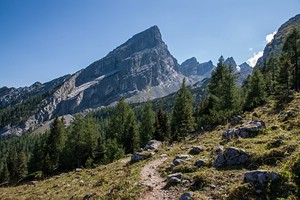 After an hour we start the hike back down. Shortly before Falzalm we take a path to the right towards Kührointalm. First we cross a meadow but then we have to climb down a rock face that is secured with steel ropes (Falzsteig). The following rocky path through a forest must be very slippery when wet. Upon exiting the forest we are met with a picturesque view of the Kührointalm huts bathed in the sun with cows on the pastures and people sitting on the terraces drinking coffee and eating cakes. We are at 1420 metres elevation. It’s 3:40 p.m. We order apple cake, black currant spritzer and coffee and enjoy the view of the Watzmann. At 4:30 p.m. we continue on the trail downhill towards Schapbachalm taking a steep path that cuts through the forest at first instead of the road. Shortly after the Alm we are back the first crossroads. It’s 5:15 p.m. After another 30 minutes and a total of 8.5 hours we are back at the carpark. The total trail length was indicated with 15 km. On the return to Schönau we stop at the supermarket in Berchtesgaden where we buy some sandwiches for dinner. Sunday, September 13: Salzburg and Gollinger Waterfall Weather: a.m. sunny, p.m. cloudy, max. 25 °C 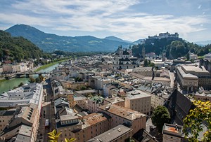 It’s
the perfect weather for our wedding anniversary! After breakfast we
check out of Pension Grünsteinblick and drive to Berchtesgaden where
we drive up the road „Zum Lockstein“ for the view with the Watzmann
in the background. On the way to the Austrian border we pass by the
parking area for the hike to the Schellenberger Ice Cave and today
on a sunny Sunday it is already overflowing! It’s
the perfect weather for our wedding anniversary! After breakfast we
check out of Pension Grünsteinblick and drive to Berchtesgaden where
we drive up the road „Zum Lockstein“ for the view with the Watzmann
in the background. On the way to the Austrian border we pass by the
parking area for the hike to the Schellenberger Ice Cave and today
on a sunny Sunday it is already overflowing!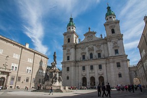 At 10:15 a.m. we park in the city centre of Salzburg and start on a sightseeing tour. We wander by the cathedral and Mozart‘s birthplace. Then we take the elevator for 2.50 euros each onto Mönchsberg which hosts the Museum der Moderne. From there you can walk (approx. 1 km) to Richterhöhe (with 508 metres above sea level the highest point of the Mönchsberg). From the other side you can access Hohensalzburg castle (8 euros if you walk up from the city centre or 11.50 euros if you use the elevator access). But we haven’t planned on visiting it. Instead we walk back to the old town and to the shore of the Salzach at Mozartsteg. 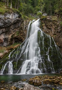 After 2.5 hours we are ready to continue our journey.
We drive over to Hangar 7 at Salzburg Airport. Entry to the permanent exhibition of aircrafts and racing cars is free. At 1:30 p.m. we drive south on the motorway and after 30 minutes we have reached Golling. A narrow road leads to the parking area of the Gollinger Wasserfall. We pay 2.50 euros each and it’s a short walk to the lower waterfall which has a height of 75 metres. From here many stairs lead to the upper fall with a height of 25 meters and to the source where the water exits the mountain. We spend some time to photograph and after an hour we return to the car. But before we continue, we stop at the local inn for coffee and cake. It’s 3:30 p.m. when we continue towards Schladming where we arrive after a bit more than an hour’s drive. For 5 nights we will be staying at a holiday flat at Bio-Holzhaus Heimat (88 euros per night) in the village of Kulm close to Ramsau am Dachstein. The flat has a living room with kitchen and two bedrooms. There’s a large flat-screen tv and free wifi. There’s also a large terrace which we didn’t use as it was in shade at the end of the day and right next to the road. From the parking area you have a great view of the mountains. A bakery is close-by and to the tourist office of Ramsau it’s just a 5 minutes’ walk. Opposite of the tourist info is the Kulmwirt restaurant where we have dinner tonight which is excellent (cheese nockerl/pasta with fillet of pork and rump steak with baked potatoes). Including 2 glasses of beer and 2 two glasses of Sturm (young wine) we pay 52 euros plus tip. Monday, September 14: Wild Waters and Hochwurzen in the Schladminger Tauern Weather: changeable, 19 °C 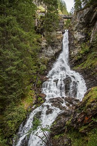 We
make ourselves breakfast with fresh rolls, boiled eggs, cheese, cold
cuts, Nutella, coffee. It’s cloudy this morning so we decide to hike
into a gorge. We leave at 9:15. From Ramsau-Kulm we drive into the
valley of Schladming and on the other side into the Rohrmooser
Untertal. There’s a charge of 7 euros to enter the valley but this
is included as one of the benefits of our free summer card that we
were given with our accommodation. Unfortunately we are now getting
closer to the rain clouds at the end of the valley. After a 30
minutes’ drive we park on the last parking area (P1) and put on our
rain gear and hiking boots. The “Wilde Wasser” hike starts at the
Riesachfall inn. We
make ourselves breakfast with fresh rolls, boiled eggs, cheese, cold
cuts, Nutella, coffee. It’s cloudy this morning so we decide to hike
into a gorge. We leave at 9:15. From Ramsau-Kulm we drive into the
valley of Schladming and on the other side into the Rohrmooser
Untertal. There’s a charge of 7 euros to enter the valley but this
is included as one of the benefits of our free summer card that we
were given with our accommodation. Unfortunately we are now getting
closer to the rain clouds at the end of the valley. After a 30
minutes’ drive we park on the last parking area (P1) and put on our
rain gear and hiking boots. The “Wilde Wasser” hike starts at the
Riesachfall inn.
 We
climb up some stairs through the forest and soon we have reached the
first viewpoint of the Riesach waterfall. The upper and lower
Riesachfall have a total height of 140 metres which makes them the
highest waterfall of the Steiermark region. The rain has stopped and
the trail climbs further up until we cross a bridge from where we
can see the suspension bridge across the gorge which is part of the
alpine trail „Durch die Höll“ (‘Through Hell’). Höll is the name of
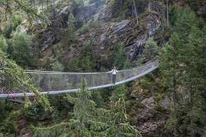
the gorge. The suspension bridge is 46 metres long and 35 metres
high. It was built in 2005. The trail is built into the gorge over
many iron stairs and ladders. It’s quite busy right now with many
people in the gorge as a tour bus had just arrived with us. After 1
hour and 20 minutes we have reached the top at Gfölleralm at 1357
metres elevation. We climbed a total of 280 metres elevation. A
short way behind the hut is a view of Lake Riesach. We return on the
forest road which loops around the gorge. At 12 p.m. we are back at
the car. We
climb up some stairs through the forest and soon we have reached the
first viewpoint of the Riesach waterfall. The upper and lower
Riesachfall have a total height of 140 metres which makes them the
highest waterfall of the Steiermark region. The rain has stopped and
the trail climbs further up until we cross a bridge from where we
can see the suspension bridge across the gorge which is part of the
alpine trail „Durch die Höll“ (‘Through Hell’). Höll is the name of
the gorge. The suspension bridge is 46 metres long and 35 metres
high. It was built in 2005. The trail is built into the gorge over
many iron stairs and ladders. It’s quite busy right now with many
people in the gorge as a tour bus had just arrived with us. After 1
hour and 20 minutes we have reached the top at Gfölleralm at 1357
metres elevation. We climbed a total of 280 metres elevation. A
short way behind the hut is a view of Lake Riesach. We return on the
forest road which loops around the gorge. At 12 p.m. we are back at
the car.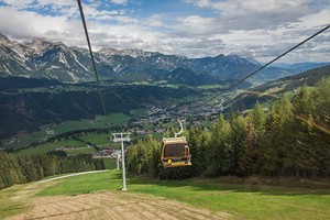 We
return to Rohrmoos and park at the lower station of the Hochwurzen
cable car. 1 cable car ride (ascent and descent) per day is also
included in the summer card. The regular price is 13 euros. At the
summit station we are at 1850 metres above sea level. We have 13 °C.
Hochwurzen provides a great view of the Dachstein mountain range on
the other side of the valley. We have lunch at the Hochwurzen hut
(Wurstsalat which is a salad made of strips of sausage, onions,
gherkins with oil and vinegar dressing, and a Wiener Schnitzel with
potatoes). Then we start on a short loop walk. The cloudy weather
does not motivate us to stay out long so we are back after 20
minutes. It starts to rain again and we take the next cable car back
down. We
return to Rohrmoos and park at the lower station of the Hochwurzen
cable car. 1 cable car ride (ascent and descent) per day is also
included in the summer card. The regular price is 13 euros. At the
summit station we are at 1850 metres above sea level. We have 13 °C.
Hochwurzen provides a great view of the Dachstein mountain range on
the other side of the valley. We have lunch at the Hochwurzen hut
(Wurstsalat which is a salad made of strips of sausage, onions,
gherkins with oil and vinegar dressing, and a Wiener Schnitzel with
potatoes). Then we start on a short loop walk. The cloudy weather
does not motivate us to stay out long so we are back after 20
minutes. It starts to rain again and we take the next cable car back
down.At 2 p.m. we are back at the car and decide to go to the indoor swimming pool (Erlebnisbad) in Schladming. This is also included in the summer card. The regular price for 3 hours at the pool is 10.50 euros. As it’s a weekday afternoon we have the pool much to ourselves. We enjoy the „Black Hole“ slide, waterfalls, wave rides and jet stream canal. But after 45 minutes of this we get bored and drive to the centre of Schladming. We also do some shopping for food at the Spar supermarket and we have coffee and cake at a café. It’s 5 p.m. when we return to our accommodation. For dinner we have pasta with tomatoes. Tuesday, September 15: e-bike tour to Rittisberg Weather: cloudy with sunny spells, 19 °C After breakfast we check by the tourist information around the corner and ask about a glacier hike on the Dachstein mountain and if we need a reservation for the cable car. They tell us that they would recommend a guided tour which is free and one is planned for the day that we have envisioned so we sign up. Then we ask about a bike rental and are told to check at Intersport Bachler in the village centre of Ramsau. 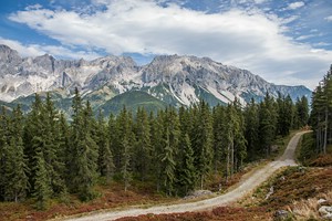 We sign up for two mountain e-bikes and start off at 9:30 a.m. It’s
a loop around the Rittisberg mountain via Greimelbacher, Halseralm,
Sonnenalm and Wiesmahdalm. We seem to lose track in the forest and
have to push the bikes up a narrow path to get back onto the forest
road (Panoramarundweg Süd). At 12 p.m. we have reached the summit.
There’s a large cross and a lookout tower which offers a fabulous
360° view of the Dachstein (3004m) on one side and the Schladminger
Tauern and the Großglockner mountain range on the other.
We sign up for two mountain e-bikes and start off at 9:30 a.m. It’s
a loop around the Rittisberg mountain via Greimelbacher, Halseralm,
Sonnenalm and Wiesmahdalm. We seem to lose track in the forest and
have to push the bikes up a narrow path to get back onto the forest
road (Panoramarundweg Süd). At 12 p.m. we have reached the summit.
There’s a large cross and a lookout tower which offers a fabulous
360° view of the Dachstein (3004m) on one side and the Schladminger
Tauern and the Großglockner mountain range on the other.A short way back takes us to the main path and to the Rittisstadl hut where we have lunch (Eiernockerl pasta with salad and the Rittispfandl with egg, cheese and bacon) on the sunny terrace. 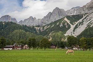 Afterwards it’s a long downhill ride on a forest road that
ends at the Ramsau Beach recreation park. By now it’s hard to sit on
the small saddles. We continue on the Ramsauer Panoramaweg (No. 1)
via Lärchenhof and Knollhof. At Felstererhof there’s another long
descent on a tarred road until Rössingstraße and back to the main
road. At 2:40 p.m. we are ready to return our bikes. With just 20
euros per person we get a good price including summer card discount.
According to our GPS we covered 32 kilometres with 990 metres
elevation gain (seems a lot more than I would have guessed). We have
an ice-cream in Ramsau and on the way back to our accommodation we
stop at the supermarket.
Afterwards it’s a long downhill ride on a forest road that
ends at the Ramsau Beach recreation park. By now it’s hard to sit on
the small saddles. We continue on the Ramsauer Panoramaweg (No. 1)
via Lärchenhof and Knollhof. At Felstererhof there’s another long
descent on a tarred road until Rössingstraße and back to the main
road. At 2:40 p.m. we are ready to return our bikes. With just 20
euros per person we get a good price including summer card discount.
According to our GPS we covered 32 kilometres with 990 metres
elevation gain (seems a lot more than I would have guessed). We have
an ice-cream in Ramsau and on the way back to our accommodation we
stop at the supermarket. After taking a shower we get into the car again and drive down into the valley via Vordere Ramsau and Weißenbach. There’s a 3 euro fee for the narrow road to Steirischer Bodensee that’s also included in the summer card but at 5:30 p.m. the pay station is no longer manned. From the parking area it’s a 10 minutes’ walk to the lake which lies at the end of the valley surrounded by steep mountains. There’s a waterfall on the other side of the lake which requires a 30 minutes’ walk but it's already late in the day and the sun has disappeared behind the mountains. We return to our holiday flat. For dinner we have pasta with chicken. Wednesday, September 16: Hike below the Dachstein south face to the Tor gap Weather: first cloudy, then mostly sunny, approx.. 24 °C After breakfast it’s 8:45 a.m. when we leave for Ramsau village and the Dachstein mountain. The Dachsteinstraße charges 14 euros but this is included in our summer card. We park at the end of the road at the cable car station Türlwand at 1700 metres above sea level. It’s 9:15 when we start our hike. From the cable car station a narrow path leads up to the Südwandhütte (1910m) in 40 minutes. From the terrace of this mountain hut we get a great view of the Dachstein south face and the hiking trail that we plan to follow. | ||||||
 | ||||||
|
The path goes downhill at first, then across a field of debris, and
then up some switchbacks on a rocky trail and through a gap called
the “Tor” (gate) between the mountains Raucheck and Torstein. After two hours since leaving the Südwandhütte, we have reached the Tor. It’s 12:15 p.m. and we have a little lunchbreak with some granola bars and a great view. The descent is not as steep as the ascent but there’s another field of debris to cross which can be a bit of a challenge due to the loose gravel. By 2 p.m. we arrive at the Bachlalm. Here we have Kaiserschmarren and a salad. After an hour’s rest we continue our hike, it still goes downhill for a bit, then up again with some great views at Maralmboden and Neustattalm with its unserviced huts. After 1.5 hours we are back at the Türlwand parking. It’s 4:30 p.m. Overall we hiked a bit more than 7 hours covering 14 kilometres with an elevation gain of 890 metres according to our GPS. We return to our holiday flat. For dinner we have the same as yesterday but freshly cooked. Thursday, September 17: Hike to Dachstein glacier and Guttenberghaus Weather: mostly cloudy, 7 °C on the glacier, otherwise 25 °C 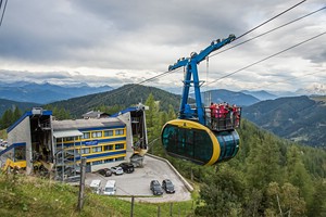 Today
we get up early, have breakfast with some fresh rolls from the
bakery and go outside to wait at the bus stop in front of the house.
The bus is scheduled for 7:33 but it’s running 15 minutes late. When
it arrives, it’s full of pupils but the few hikers also squeeze in.
With the summer card it’s free got us. The bus drives up the
Dachsteinstraße and we get off at the Türlwand cable car station
where we parked yesterday. The two hiking guides brief the group of
25 participants that have signed up for the glacier tour. They told
us that during the summer months they had groups of up to 80 people! Today
we get up early, have breakfast with some fresh rolls from the
bakery and go outside to wait at the bus stop in front of the house.
The bus is scheduled for 7:33 but it’s running 15 minutes late. When
it arrives, it’s full of pupils but the few hikers also squeeze in.
With the summer card it’s free got us. The bus drives up the
Dachsteinstraße and we get off at the Türlwand cable car station
where we parked yesterday. The two hiking guides brief the group of
25 participants that have signed up for the glacier tour. They told
us that during the summer months they had groups of up to 80 people!There’s no queue yet at the gondola which will fit 54 passengers. One ascent and descent per week is also included in the summer card. If you manage to get on the panorama gondola, you can stand on its roof during the ride! 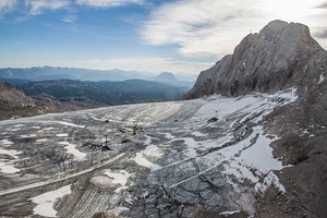 Our gondola departs at 8:15 a.m. At 8:45 a.m. our group is supposed to meet at the upper station. But I also want to go onto the suspension bridge (Dachstein Skywalk) which was built in 2013 and is in the highest location in Austria at 2700 metres above sea level. There’s a charge of 3 euros. I quickly walk onto the bridge where a strong wind is blowing with 60 kilometres per hour. I walk to the other side to the „Stairs to Nowhere“ for the view down the face of the mountain. 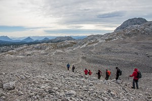 Then
we catch up with the group and start our descent onto the
Schladminger glacier. There’s ice on the way down so it’s very
slippery. Then we walk across the ice field which is groomed by
snowcats. This is a ski area during winter. Today we have 7 °C. Our
guides say that they have never seen the glacier melt as much as
this year with its very warm summer. Afterwards we continue through
a landscape of debris and rocks, called „Landschaft am Stein“. There
are some tricky descents due to the loose rocks. The group splits
into a faster and a slower group. The sky is a bit overcast but it’s
not cold because of the warm Foehn wind. Then
we catch up with the group and start our descent onto the
Schladminger glacier. There’s ice on the way down so it’s very
slippery. Then we walk across the ice field which is groomed by
snowcats. This is a ski area during winter. Today we have 7 °C. Our
guides say that they have never seen the glacier melt as much as
this year with its very warm summer. Afterwards we continue through
a landscape of debris and rocks, called „Landschaft am Stein“. There
are some tricky descents due to the loose rocks. The group splits
into a faster and a slower group. The sky is a bit overcast but it’s
not cold because of the warm Foehn wind.
 Our
guides talk about a group that froze to death up here when there was
an unforeseen change in the weather that they ignored. We walk
mostly downhill and eventually the trail leads down the
Feistererscharte which is secured with ropes. Our guides help out
some people who feel a bit insecure. Then we can see our
destination, the Guttenberghaus at 2146 metres elevation, and the
wind is blowing with 80 km/h when we make the final descent to the
hut. After 4 hours’ hike we enter the hut. It’s 12:45 p.m. Our
guides talk about a group that froze to death up here when there was
an unforeseen change in the weather that they ignored. We walk
mostly downhill and eventually the trail leads down the
Feistererscharte which is secured with ropes. Our guides help out
some people who feel a bit insecure. Then we can see our
destination, the Guttenberghaus at 2146 metres elevation, and the
wind is blowing with 80 km/h when we make the final descent to the
hut. After 4 hours’ hike we enter the hut. It’s 12:45 p.m.
 The
group dissolves, our guides say good-bye and we have lunch (pea
soup) in the hut as it’s too windy outside. The
group dissolves, our guides say good-bye and we have lunch (pea
soup) in the hut as it’s too windy outside.After 45 minutes we start the final descent of another 1000 metres to Ramsau which is following a broader trail with many switchbacks. After 1.5 hours we make a small detour to Lärchenbodenalm where we have walnut cake, coffee, black currant spritzer, a beer and a blackberry liqueur. The hosts of the Alm are 2 young men and 2 young ladies wearing traditional Dirndl and Lederhosen and playing the accordion. We enjoy sitting outside in the sunshine and after 45 minutes we continue on our way. At 4:15 p.m. we arrive at the Feistererhof in Ramsau. Instead of returning onto the main road we follow a path across a meadow and then through the forest and along a stream (Ramsaubach) back to Kulm. It’s 5:15 p.m. when we arrive at our accommodation. According to our GPS we have walked approx. 17 kilometres with a total descent of 1500 metres. For dinner we return to the Kulmwirt restaurant where we have the goulash with pasta (Nockerln) with a beer and a Sturm. Friday, September 18: Drive to Tölz Weather: cloudy, approx. 18 °C 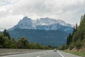 Today
is our day of departure. We check out of our accommodation at 9 a.m.
and return to the motorway via Filzmoos. At 10:25 we are stuck in
the traffic jam at the Walserberg border near Salzburg. Since one
week ago border controls have been reintroduced due to the huge
floods of refugees coming to Europe and Germany from Syria and other
countries. It takes us an hour and 15 minutes until we can pass. Today
is our day of departure. We check out of our accommodation at 9 a.m.
and return to the motorway via Filzmoos. At 10:25 we are stuck in
the traffic jam at the Walserberg border near Salzburg. Since one
week ago border controls have been reintroduced due to the huge
floods of refugees coming to Europe and Germany from Syria and other
countries. It takes us an hour and 15 minutes until we can pass. At 12:30 p.m. we leave the motorway shortly after Rosenheim. Another 30 minutes takes us to Bad Tölz where we visit the historic centre with its painted houses (Lüftlmalerei). We have a quick lunch at a butcher and after another hours’ drive we arrive at my sister’s place where we spend the last evening of our trip. Saterday, September 19: Return to Düsseldorf Weather: a mix of sun and clouds, two quick rain showers, approx. 18 °C After breakfast we depart around 9 a.m. There’s no traffic jam on the German motorways that delays our return. We make a short stop at McDonalds and get back home around 4 p.m. |


|
|