| |
 |
 |
 |
Saturday,
12th May, a.m. sunny, p.m. partly cloudy, approx. 30 ░C
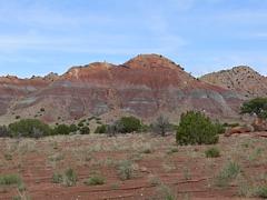
Three Rivers Petroglyph Site - Valley of Fires - Salinas Pueblo Missions
Accommodation: Club House Inn, Albuquerque
Miles driven: 241
 We
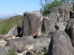
left at 8:30 a.m. and drove to Three Rivers Petroglyph Site ($2
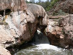
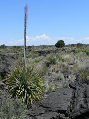
or national parks pass). The trail was one mile return. The next stop was Valley of Fires,
where we arrived at 11 a.m. This was only a short trail on a tarred track. We
left at 8:30 a.m. and drove to Three Rivers Petroglyph Site ($2
or national parks pass). The trail was one mile return. The next stop was Valley of Fires,
where we arrived at 11 a.m. This was only a short trail on a tarred track.
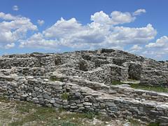
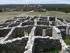
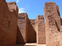
At 1 p.m. we reached Gran Quivira, our first stop of the three Salinas Pueblo
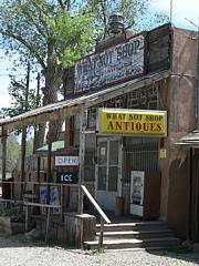
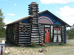
Missions. At Montainair we stopped at Rancho Bonito of Pop Shaffer. At 2:40 p.m.
we arrived at Quarai, another of the Salinas Missions. We also did the 1-mile
loop Spanish Corral Trail. We didn't visit the third mission: Ab¾ which would
have meant an
18
miles detour.
At 5 p.m. we arrived in
Albuquerque. We had booked a room at
Club House Inn
for three nights ($72
+ Tax AAA Rate). This is a very central location at the I-40/I-25
and not far from the Old Town.
We had dinner at
66 Diner on historic
Route 66
(Central NE).
 Sunday,
13th May, sunny, 30 ░C Sunday,
13th May, sunny, 30 ░C
Turquoise Trail - Kasha-Katuwe Tent Rocks
Accommodation: Club House Inn, Albuquerque
Miles driven: 180
After
a free buffet breakfast at the hotel we drove up to Sandia Peak ($3 or
national parks pass). This is at an elevation of
3000m with a great eagle's eye view of Albuquerque. This is also
a skiing area in winter. You can also go up by cable car.
Then we drove the
Turquoise Trail
in the direction of Santa Fe. There are three ghost towns on this route: Golden, Madrid
and Cerrillos.
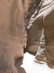 Via Cochiti Pueblo and a few
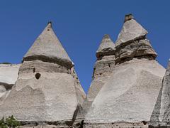
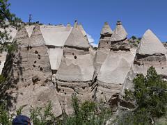
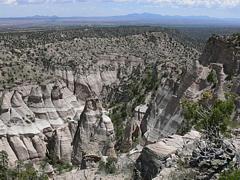
miles on a gravel road we reached the
Kasha-Katuwe Tent Rocks
at 1 p.m. Here we did the 1.5 miles long (one-way) Canyon Tail. This
passes through a slot canyon and then to the valley of tent
rocks. We climbed up to the canyon rim where we had a great view. At the
end we also did the Cave Loop Trail.
We were back at the car park after a bit more than 2 hours. Via Cochiti Pueblo and a few
miles on a gravel road we reached the
Kasha-Katuwe Tent Rocks
at 1 p.m. Here we did the 1.5 miles long (one-way) Canyon Tail. This
passes through a slot canyon and then to the valley of tent
rocks. We climbed up to the canyon rim where we had a great view. At the
end we also did the Cave Loop Trail.
We were back at the car park after a bit more than 2 hours.
We continued the gravel road for another 3.5 miles to VeteransÆ Memorial Scenic Overlook (or Ca±ada Kamada Overlook).
Then we reached Indian reservation area (No Trespassing). We were back
at the hotel at 5 p.m. and went to a Mexican restaurant for dinner.
|
 |
 |
 |
 |
Monday, 14th May, cloudy with occasional sunshine
and local
thunderstorms, 25 ░C
El Malpais NM - El Morro NM
Accommodation: Club House Inn, Albuquerque
Miles driven: 180We got on the road at
8:40 a.m. and drove on the I-40
towards Grants. It were
70
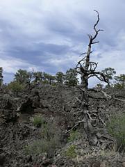
miles to El Malpais National Monument, about a good hour's drive. El Malpais is
Spanish for badlands. We were advised by the rangers not to drive the Chain of Craters Backcountry Byway
as this dirt road could still be muddy after the rainfalls the day before.
We drove to Sandstone Bluffs Overlook and La Ventana
Natural Arch and through the Narrows with lava fields to the right and sandstone
cliffs to the left. Shortly after 11 a.m. we reached the trailhead to the Lava Falls Area. 1.2
miles and 45 mins. later we continued to the Chain of Craters Byway but a
rain front was coming up, so we turned back the 36 miles to the interstate.
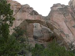
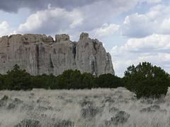
After a lunch stop in Grants at 1 p.m. we drove to El Morro National Monument, another 40 miles from Grants.
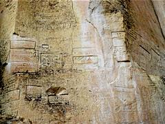
When we got there it started to rain. Lightning was flashing over the rock of El Morro,
this was impressive! In any case we did the 0.5 miles Inscription Rock Trail at
the base of the rock. There's a waterhole at the base of the rock where the
first settlers left their inscriptions on their journey to the west.
In this weather it wasn't a good idea to climb to the top of the rock on the 2
miles Mesa Top Loop Trail.
 So
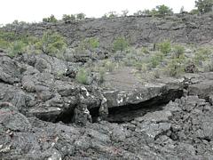
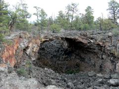
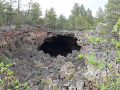
we turned back and the rain stopped shortly afterwards. We turned into the Chain of Craters Byway
from the other side to reach the Big Tubes Area. The 7 miles long route was
definitely not suitable for normal cars in its current condition. When wet the
road becomes impassable even for 4-wheel drive. But we took the risk with the
rainfront in our back. The road was mostly dry. Shortly before 4 p.m. we started
off on the 2 miles loop trail. This was one of the best hikes we did. We climbed
across lava rocks following stone cairns. The lava caves and bridges we saw were
impressive. We passed Seven Bridges, Four Windows Cave, Caterpillar Collapse and Big Skylight Cave
on the way. After 1.5 hours were were back at the car. We met noone on this
trail. So
we turned back and the rain stopped shortly afterwards. We turned into the Chain of Craters Byway
from the other side to reach the Big Tubes Area. The 7 miles long route was
definitely not suitable for normal cars in its current condition. When wet the
road becomes impassable even for 4-wheel drive. But we took the risk with the
rainfront in our back. The road was mostly dry. Shortly before 4 p.m. we started
off on the 2 miles loop trail. This was one of the best hikes we did. We climbed
across lava rocks following stone cairns. The lava caves and bridges we saw were
impressive. We passed Seven Bridges, Four Windows Cave, Caterpillar Collapse and Big Skylight Cave
on the way. After 1.5 hours were were back at the car. We met noone on this
trail.
Via Zuni Canyon we drove back to Grants. We didn't make it to Bandera Crater
and Ice Cave and to the El
Calderon Area today. We were back in Albuquerque shortly after 7:30 p.m. We
managed to see the Old Town Plaza in the light of the setting sun. It has a
beautiful church. We had dinner at ApplebeeÆs on Menaul Boulevard.
|

 |
Tuesday, 15th May, partly cloudy, approx. 20 ░C
Ojito Wilderness, Jemez Mountain
Trail, Bandelier NM
Accommodation: Super 8, Santa Fe
Miles driven: 177
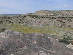
We left at 9 a.m. Our first destination for this day was the
Ojito Wilderness near San Ysidro. Via a dirt road, Cabezon Road, we
reached the trailhead to the Pu±i Views Hike after 10 miles.
Here
are the directions and a description of the trails. The Pu±i Views Hike
leads to a viewpoint with some petroglyphs. It is 1.2 miles.
Then we drove the
Jemez Mountain
Trail between San Ysidro and Los Alamos, passing by Soda Dam, Battleship
Rock, missing Spence Hot Springs somehow, and the Jemez Caldera or Valle Grande,
with an extension of 14 miles one of the largst volcanic craters in the world.
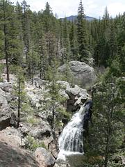
We also did a short hike to Jemez Falls.
Around 3 p.m. we arrived at
Bandelier National Monument ($12
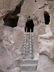
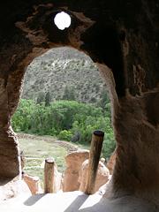
or National Parks Pass).We walked the Main Loop Trail to the Big Kiva and
several cliff dwellings (Tyuonyi, Talus House and Long House) and did a 1-mile (return)
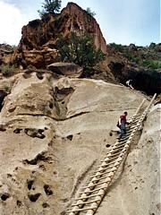
detour to Alcove House (Ceremonial Cave);
here
is a trail description. You have to climb up a ladder of 140 ft. to see the
cliff dwelling. We left the park after two hours, and after another stop at
White Rocks Overlook with a view of the Rio Grande and the snow-capped Sangre de
Cristo Mountains we arrived in Santa Fe at 6 p.m. Here we had booked a
room at
Super 8 ($52
+ Tax AAA Rate) for two nights.
Wednesday, 16th May, a.m. cloudy, pm. partly cloudy, approx.
20 ░C
Santa Fe - High Road to Taos - Taos Pueblo - Rio Grande Gorge
Accommodation: Super 8, Santa Fe
Miles driven: 185
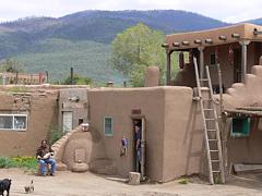
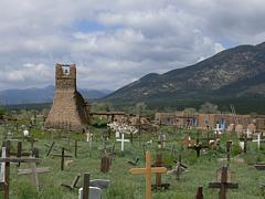
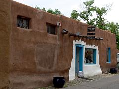
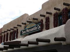
This morning we got on the road at 9 a.m. We visited the Old
Town of Santa Fe first with the San Miguel Mission, Loretto Chapel, the
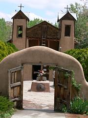
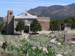
Cathedral Basilica of St. Francis de Assisi and the Plaza of course. Via Chimay¾
with its beautiful adobe church we reached the High Road to Taos where we
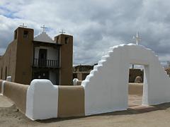
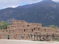
arrived around 1 p.m. We visited
Taos Pueblo ($10
each plus $5 per camera). This Indian village is still inhabited, so it was an
interesting visit. Taos itself also has a nice plaza.
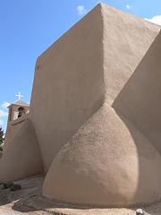
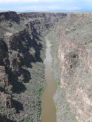
We continued on our way at 2:45 p.m. Our next stop was the Rio
Grande Gorge Bridge, then the San Francisco de Asis Church in Ranchos de Taos.
We followed the Rio Grande back to Santa Fe.
|
 |
 |
 |
 |
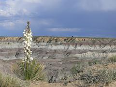
Thursday, 17th May, partly cloudy, 26 ░C
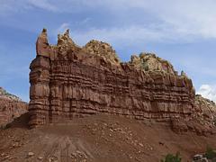
Abiquiu - Chaco Canyon - Angel Peak
Accommodation: The Region Inn, Farmington
Miles driven: 302
 Shortly
after 8 a.m. we left Santa Fe in the direction of Abiquiu which also has a nice
adobe church. We drove to Ghost Ranch where Georgia O'Keefe lived and where you
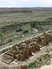
can find some red rocks and colourful badlands. Via Cuba we continued to Chaco
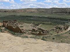
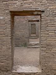
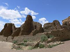
Canyon, or Chaco Culture National Historic Park ($8 or National Park's Pass)
which can be reached via a
16 miles long dirt road. We arrived here at 1:30
p.m. and had a look at Pueblo Bonito, some petroglyphs on a cliff wall, Chetro
Ketl and Pueblo Arroyo. On the Pueblo Alto Trail we hiked to the Pueblo Bonito
Overlook (1 mile one way). Shortly
after 8 a.m. we left Santa Fe in the direction of Abiquiu which also has a nice
adobe church. We drove to Ghost Ranch where Georgia O'Keefe lived and where you
can find some red rocks and colourful badlands. Via Cuba we continued to Chaco
Canyon, or Chaco Culture National Historic Park ($8 or National Park's Pass)
which can be reached via a
16 miles long dirt road. We arrived here at 1:30
p.m. and had a look at Pueblo Bonito, some petroglyphs on a cliff wall, Chetro
Ketl and Pueblo Arroyo. On the Pueblo Alto Trail we hiked to the Pueblo Bonito
Overlook (1 mile one way).
We left the park at 4:30 p.m. and stopped once more at the
Scenic Overlook at Angel Peak south of Bloomfield with a view of some beautiful
badlands.
We reached Farmington at 6:30 p.m. Here we had booked two
nights at
The Region Inn
($65
+ Tax AAA Rate).
|
 |
 |
 |
 |
 Friday, 18th May, a.m. sunny, p.m. cloudy Friday, 18th May, a.m. sunny, p.m. cloudy
with local
thunderstorms, approx. 28 ░C
Bisti Wilderness - Aztec Arches
Accommodation: The Region Inn, Farmington
Miles driven: 233
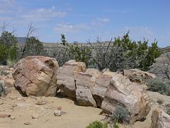
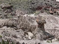
We
left Farmington at 8:15 a.m. to see the
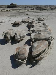
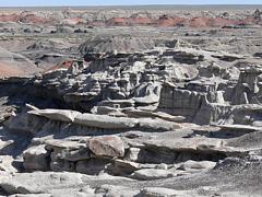
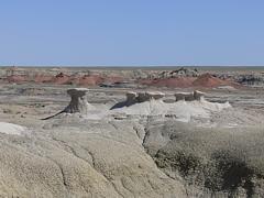
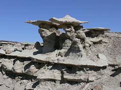
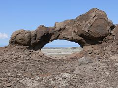
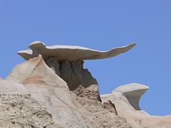
Bisti Wilderness. Bisti
is badlands in Navajo. Access is 35 miles south of Farmington via 3 miles
of dirt road. We had found GPS details on some German internet sites. We
found the Brown Hoodoos, the Bisti Arch, the Cracked Eggs, the EagleÆs
Nest, the Valley of the Bones and the Stone Wings. It got quite hot around noon.
After 4 hours and 13.5 km we were back at the car.
 We drove back to Farmington and in
the afternoon we turned from hoodoo hunters to arch hunters, trying to locate
the
Aztec Arches.
Here
are some tour descriptions. It's quite amazing how quickly the weather
can change sometimes and how locally different it can be.
We were now driving right into the thunderstorm while it was still dry south of
Farmington. But
at least it stopped after a while. We were a bit apprehensive of
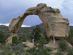
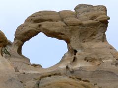
driving dirt roads in this weather. We found the Arch Rock, the Anazasi Arch or Cox Canyon Arch
(we had to do some rock climbing to get to it), Petroglyph Arch, and Rooftop Arch. We drove back to Farmington and in
the afternoon we turned from hoodoo hunters to arch hunters, trying to locate
the
Aztec Arches.
Here
are some tour descriptions. It's quite amazing how quickly the weather
can change sometimes and how locally different it can be.
We were now driving right into the thunderstorm while it was still dry south of
Farmington. But
at least it stopped after a while. We were a bit apprehensive of
driving dirt roads in this weather. We found the Arch Rock, the Anazasi Arch or Cox Canyon Arch
(we had to do some rock climbing to get to it), Petroglyph Arch, and Rooftop Arch.
At the end of the day we drove to Navajo Dam which took a bit
longer than expected. We were back in Farmington at 8 p.m. and went to the
Mexican next door for dinner.
|
 |
 |
 |
 |
|
|