| |
 |
 |
 |
 |
 |
 |
 |
 |
 |
Saturday,
13th September,
22 ░C, sunny
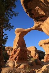
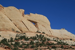
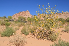
Five Hole Arch, Strike Valley Overlook
Total Miles: 241
Accommodation: Rainbow Country
B&B, Escalante
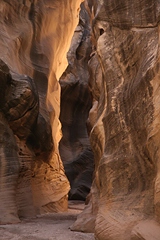
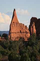
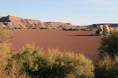
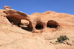
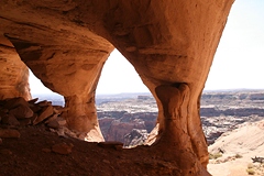
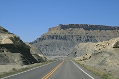
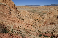
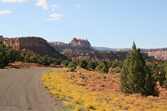
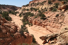
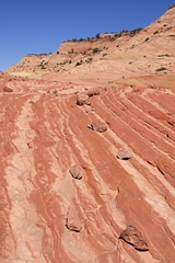
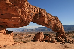
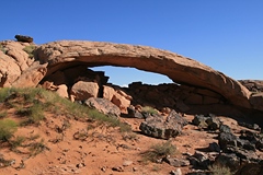
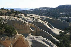
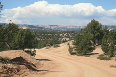
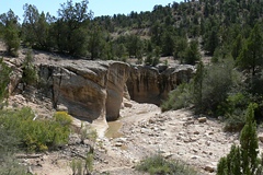
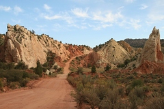
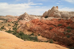
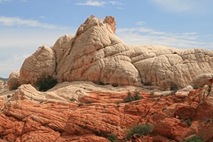
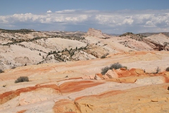
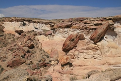
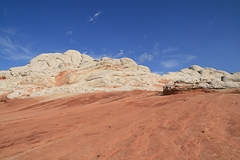
 From Green River we took a dirt road south which leads to Horseshoe
Canyon. Our first stop was at the cold water geyser of Old Chaffin Ranch
and after 36 miles we took the turn-off to
Five Hole bzw. Colonnade
Arch which we reached after a 4.6 miles hike passing by Crocodile
Rock on the way. From Green River we took a dirt road south which leads to Horseshoe
Canyon. Our first stop was at the cold water geyser of Old Chaffin Ranch
and after 36 miles we took the turn-off to
Five Hole bzw. Colonnade
Arch which we reached after a 4.6 miles hike passing by Crocodile
Rock on the way.
It
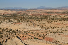
was 12 p.m. when we continued on our trip. After another 35 miles we
reached Highway 24. We passed through Hanksville and at 2 p.m. we turned
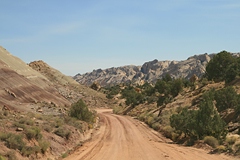
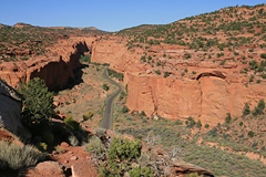
off onto Notom Bullfrog Road. Another 34
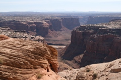
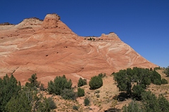
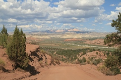
miles of dirt road to the Burr Trail Switchbacks. We took the 4WD road
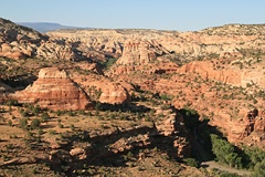
to Strike Valley Overlook. After a short hike of 0.5 miles we arrived at
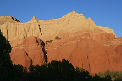
a fantastic viewpoint across the Waterpocket Fold.We also discovered a
small arch above the road.
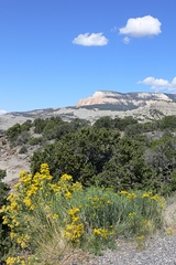
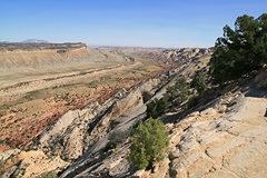
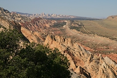
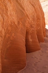
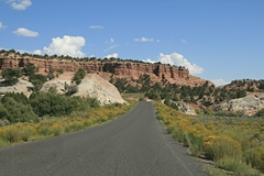
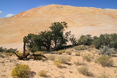
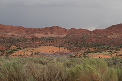
 Afterwards we drove through Long Canyon with its
impressive
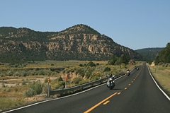
red walls. It was 5 p.m. when we reached Boulder. I think Highway 12 is
one of the most beautiful roads in the world. Another 28 miles till the
village of Escalante. Here we had booked three nights at Rainbow Country B&B
($62 AAA rate). Breakfast here was great: French
toast with strawberries, scrambled eggs, , American pancakes, tacos, muffins,
etc. We had dinner at the Cowboy Blues
Restaurant which we knew from a previous trips. Nothing special for our
wedding anniversary, but it was good nevertheless. Afterwards we drove through Long Canyon with its
impressive
red walls. It was 5 p.m. when we reached Boulder. I think Highway 12 is
one of the most beautiful roads in the world. Another 28 miles till the
village of Escalante. Here we had booked three nights at Rainbow Country B&B
($62 AAA rate). Breakfast here was great: French
toast with strawberries, scrambled eggs, , American pancakes, tacos, muffins,
etc. We had dinner at the Cowboy Blues
Restaurant which we knew from a previous trips. Nothing special for our
wedding anniversary, but it was good nevertheless.
|
 |
 |
 |
 |
 |
 |
 |
 |
 |
 |
Sunday,
14th September,
29 ░C, sunny
Big Horn Canyon
Total Miles: 28
Accommodation: Rainbow Country B&B, Escalante
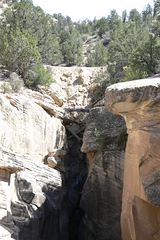
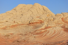
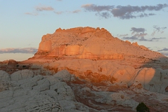
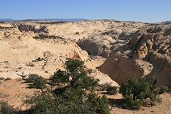
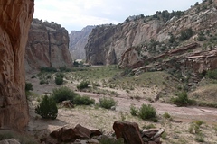
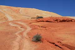
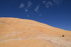
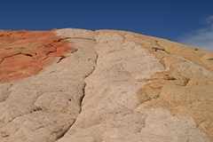
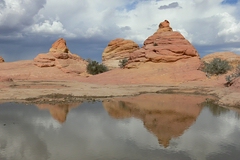
 There
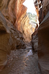
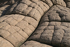
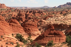
wasn't much driving today but a long hike. Big Horn Canyon was well
worth the effort. There are several slot canyons and dryfalls, not
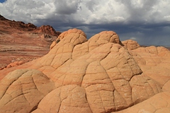
always easy to circumvent. Part of the landscape shows a lot of
simularity with the famous Wave, fossilized sand dunes. Colors are
fantastic. Once we reached the West Fork we had a look into the slot
canyon before we turned back. It was 2:30 p.m. The complete hike took 8
hours. We had covered 24 km. Two liters of water per person were not
really sufficient. It was hot. This was a very exhausting hike so we
didn't do anything else. Drove back to Escalante, had a shower and met
with Werner and his son for dinner. We knew him from an internet
community. There
wasn't much driving today but a long hike. Big Horn Canyon was well
worth the effort. There are several slot canyons and dryfalls, not
always easy to circumvent. Part of the landscape shows a lot of
simularity with the famous Wave, fossilized sand dunes. Colors are
fantastic. Once we reached the West Fork we had a look into the slot
canyon before we turned back. It was 2:30 p.m. The complete hike took 8
hours. We had covered 24 km. Two liters of water per person were not
really sufficient. It was hot. This was a very exhausting hike so we
didn't do anything else. Drove back to Escalante, had a shower and met
with Werner and his son for dinner. We knew him from an internet
community.
|
 |
 |
 |
 |
 |
 |
 |
 |
 |
 |
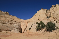
Monday,
15th September,
31
░C, sunny
HIRR:
Zebra and Tunnel Slot, Sunset and Moonrise Arch, DevilÆs Garden
Total Miles: 97
Accommodation: Rainbow Country B&B, Escalante
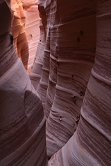
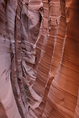
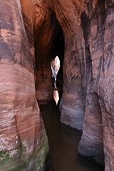
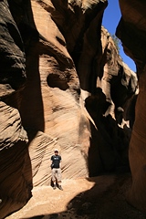
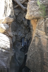
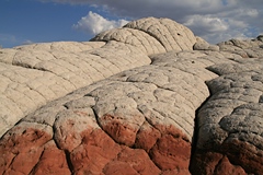
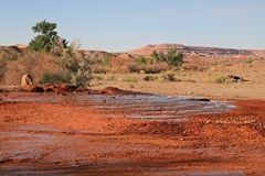
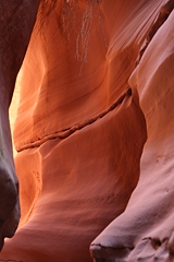
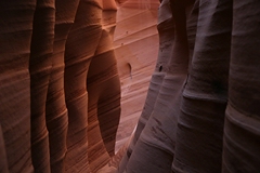
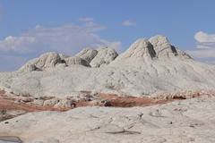
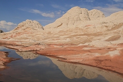
The Visitor Center in
Escalante confirmed this morning that there might be water in the Zebra
Slot, however, we decided to give it a try anyway. The trailhead is 8
miles down Hole-in-the-Rock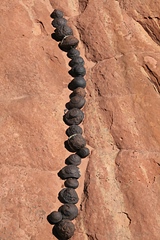 Road. It took about an hour to reach the
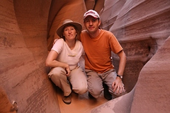
entrance to the slot, and there was no water! So we climbed in. It's a
beautiful slot, so we took lots of pictures. But getting closer to noon
there was too much sunlight in the canyon, too much contrast. At 11:30
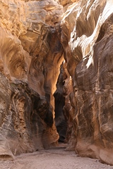
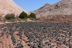
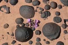
p.m. we continued our hike towards Tunnel Slot passing by fields of
Moqui marbles! There was water in the Tunnel Slot, and as we didn't feel
like wading through the murky water, we only glanced in. There was a
nice reflection in the water from the entrance on the other side. It was
1 p.m. when we turned back. Road. It took about an hour to reach the
entrance to the slot, and there was no water! So we climbed in. It's a
beautiful slot, so we took lots of pictures. But getting closer to noon
there was too much sunlight in the canyon, too much contrast. At 11:30
p.m. we continued our hike towards Tunnel Slot passing by fields of
Moqui marbles! There was water in the Tunnel Slot, and as we didn't feel
like wading through the murky water, we only glanced in. There was a
nice reflection in the water from the entrance on the other side. It was
1 p.m. when we turned back.
We continued down Hole-in-the-Rock Road
for 28 miles to Fourtymile Ridge Road, and another 4
miles to the trailhead for Sunset Arch. It was an hour's drive. It was 4
p.m., excellent late afternoon light. We visited Moonrise Arch as
well. It was 5:30 p.m when we were back at the car. We made it to
Devil's Garden just before sunset.
You will find
descriptions of today's hikes in
Laurent MartrĶs's book
äPhotographing the Southwest ¢ Southern Utahō.
Had great rainbow trouts at the Cowboy Blues. Including beer and a coke for $35.
|
 |
 |
 |
 |
 |
 |
 |
 |
 |
 |
Tuesday,
16th September,
28 ░C, sunny
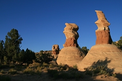
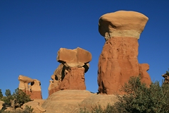
Covered Wagon Natural Bridge & Cedar Wash Arch,
Escalante Overlook, Willis Creek, Kodachrome Basin S.P.
Total Miles: 131
Accommodation: Kodachrome Basin State Park
We left Escalante via Cedar Wash Road. Along the
road you can follow short trails to Covered Wagon Natural Bridge and Cedar Wash Arch.
Back on Highway
12 we took a dirt road to Escalante Overlook.
Hiking along the canyon rim for 10 minutes you get a view Death Hollow Canyon
to the north and Escalante River Canyon to the east.
Back in Escalante we grabbed a sandwich at Subway. It was 11:30 a.m.
when we continued towards Cannonville. At the BLM Office we asked for Willis Creek Canyon.
This is 6 miles down Skutumpah Road. It's an easy hike with a few
interesting slot passages. While the best part is not far from the
trailhead we continued down the canyon for 1 hour before we turned back.
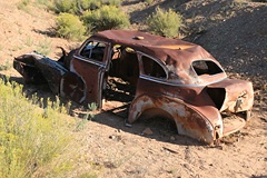
Early morning or late afternoon is best for photographs. We continued a
short distance down the road to Bull Valley Gorge, where a car crashed
down the canyon in 1954 and can still be seen below the bridge.
At 3:30 p.m. we checked into our pre-booked
cabin ($85 plus tax) in Kodachrome Basin State Park.
The cabin looked like a motel room from inside: 2 Queen beds, fridge,
microwave and bathroom, but no TV. We decided to make use of the
barbecue grill outside the cabin and drove to nearby Tropic to buy two
steaks and potato salad. While we had dinner we enjoyed the sun bathing
the red rocks of the state park in a beautiful glow. |
|
 |
 |
 |
 |
 |
 |
 |
 |
 |
Wednesday,
17th September,
28 ░C, a.m. partly cloudy, p.m. sunny
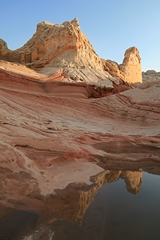
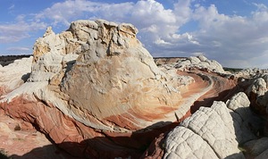
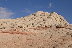
Red Top
und Yellow Rock
Total Miles: 79
Accommodation: Canyon Colors B&B,
Page
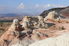
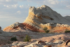
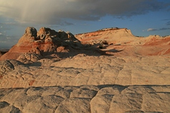
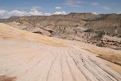
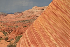
Dark rain clouds on the horizon, but
still we turned south on Cottonwood Canyon Road. After 27 miles we
reached the trailhead for today's hike. It was 9:40 a.m. We put on our
hiking boots, packed our wading boots, rain gear, food, water and off we
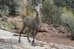
went. We had to wade through Paria River a few times, and finally
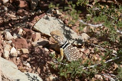
climbed up a rock face. Here we came face to face with a big horn sheep!
The trail was not easy to find, even with GPS. Actually, there was no
trail! So we followed our instinct and the few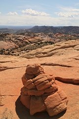 waypoints we had. We
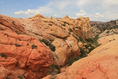
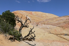
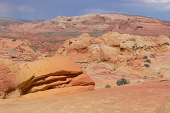
reached Red Top, a magnificently colored area of slickrock, waited a
while for better light, then continued through Yellow Rock Valley to Yellow Rock
itself. From the top of this fossilized sand dune you get a 360░ view
with Castle Rock to the north and Red Top to the south. It was 2:40 p.m.
when we left Yellow Rock. We climbed down the steep and slippery trail
and followed a wash back to the car. After almost 7 hours hiking we were
glad to rest our feet. But it was still quite a drive to the city of
Page including 12 more miles on Cottonwood Canyon
Road until we reached Highway 89. Got there at 5:45
Uhr Utah time, so it was still an hour earlier according to Arizona
time. We had booked at Canyon Colors
Bed & Breakfast for two nights
($95 incl. tax). Breakfast was good: French Toast or American Pancakes,
fresh fruit,
yoghurt, muffins. We had dinner at Fiesta Mexicana ($26 plus Tip). waypoints we had. We
reached Red Top, a magnificently colored area of slickrock, waited a
while for better light, then continued through Yellow Rock Valley to Yellow Rock
itself. From the top of this fossilized sand dune you get a 360░ view
with Castle Rock to the north and Red Top to the south. It was 2:40 p.m.
when we left Yellow Rock. We climbed down the steep and slippery trail
and followed a wash back to the car. After almost 7 hours hiking we were
glad to rest our feet. But it was still quite a drive to the city of
Page including 12 more miles on Cottonwood Canyon
Road until we reached Highway 89. Got there at 5:45
Uhr Utah time, so it was still an hour earlier according to Arizona
time. We had booked at Canyon Colors
Bed & Breakfast for two nights
($95 incl. tax). Breakfast was good: French Toast or American Pancakes,
fresh fruit,
yoghurt, muffins. We had dinner at Fiesta Mexicana ($26 plus Tip).
|
 |
 |
 |
 |
 |
 |
 |
 |
 |
 |
 |
 |
 |
 |
 |
 |
 |
 |
 |
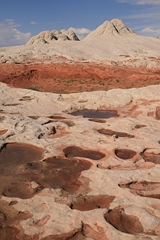
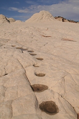
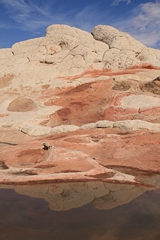
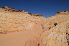
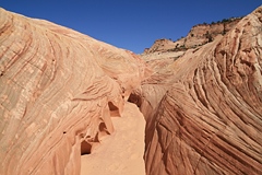
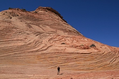
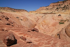
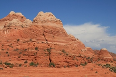
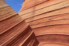
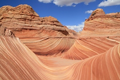
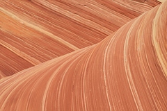
Thursday,
18th September,
29 ░C, partly cloudy, local thunderstorms
The Wave and Stud Horse Point
Total Miles: 103
Accommodation: Canyon Colors B&B,
Page
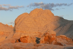
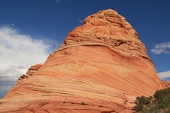
 At
8:30 a.m. we got on the road. Via Highway 89 and Houserock Valley Road
it took an hour to reach Wire Pass
trailhead. Once again (see my
travelogue of 2006) we were lucky to get permits for Coyote Buttes
North. At
8:30 a.m. we got on the road. Via Highway 89 and Houserock Valley Road
it took an hour to reach Wire Pass
trailhead. Once again (see my
travelogue of 2006) we were lucky to get permits for Coyote Buttes
North.
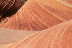
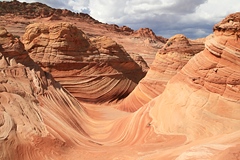
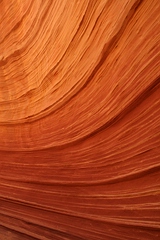
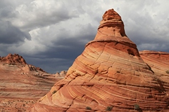
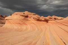
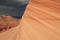
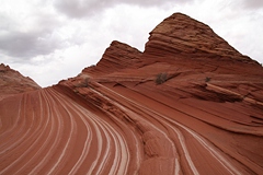
The sky was blue but they had announced thunderstoms for late afternoon.
We hoped to be back by then. Instead of rain gear we packed 3 liters
water each. As soon as we approached the Wave after a 1 hour 15 minutes
hike, dark clouds appeared. We explored the area and climbed up to Top
Rock. There was dramatic light at the Second Wave with dark clouds in
the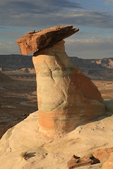 background. Eventually the rain did hit us. But it was gone as soon as
it had come. It was 4:30 p.m. when we started our hike back to the car.
background. Eventually the rain did hit us. But it was gone as soon as
it had come. It was 4:30 p.m. when we started our hike back to the car.
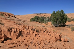
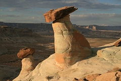
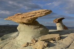
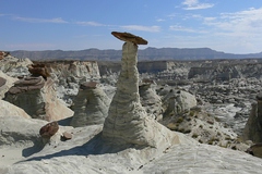
Back on Highway 89 towards Page we took a dirt road to
Stud Horse Point. The hoodoos are great
in afternoon light. By now it was 5:30 p.m. Back in Page we went to the Dam
Bar & Grille for a fish & chips dinner ($41 plus tip).
|
 |
 |
 |
 |
 |
 |
 |
 |
 |
 |
 |
 |
 |
|
|